Recently, several studies have turned their focus toward the archaeological investigation of mining regions. Looking at Kassianidou, V. et al's paper published in the journal Antiquity, this article discusses the results of a project aimed at reconstructing the ancient industrial and cultural landscape of the Skouriotissa copper mine in Cyprus, which is the island’s last operating copper mine.
A copper mine. Image Credit: Denis Zhitnik/Shutterstock.com
To date, the archaeology of mining mostly focused only on mine workings and the related technologies. However, the focus has widened in the past few decades.
The island has gained a long-established central place in metal extraction and production histories, but only very few articles report on the ancient mines of Cyprus. Such a lack of attention to mines in Cyprus is startling because the island was one of the most vital sources of copper during ancient times. Even today, it is regarded as one of the richest countries in copper by surface area.
Kassianidou, V. et al's study records the archaeology, history, and ancient environment of Skouriotissa, preserving a vital facet of Cypriot cultural heritage severely damaged by modern exploitation. The article reports on one aspect of the project: the study of the ancient mining topography of the region. This was performed with a combination of spatial data obtained from archival sources, recent fieldwork, and absolute dating. The dating specifically elucidates the pre-Byzantine history of the site.
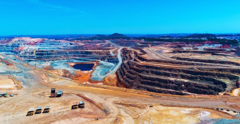
The size of the disturbed area at Skouriotissa is calculated to be about 500 ha (see Figure 1) from high-resolution satellite images. Gaining insights into the pre-modern mining landscape and the topography of Skouriotissa requires the analysis of information recorded in historical accounts, maps, photographs, reports, and aerial photographs that pre-date the open-cast operations.
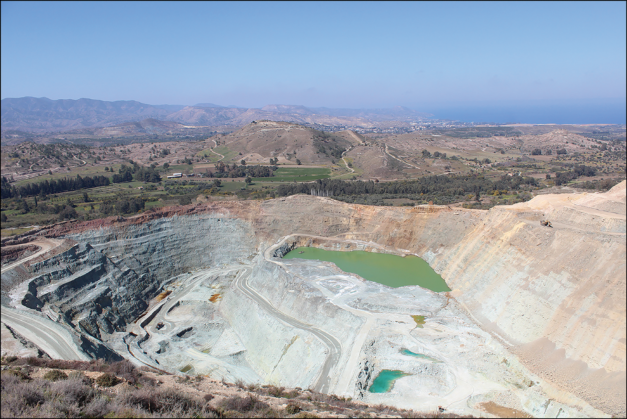
Figure 1. The modern open cast mine of Skouriotissa. Image Credit: V. Kassianidou, taken in 2014.
The richest and largest ore deposits in Cyprus are situated in the Solea Valley and mining district. The major mines in this region are Ambelikou, Mavrovouni, Skouriotissa, and Apliki (see Figure 2).
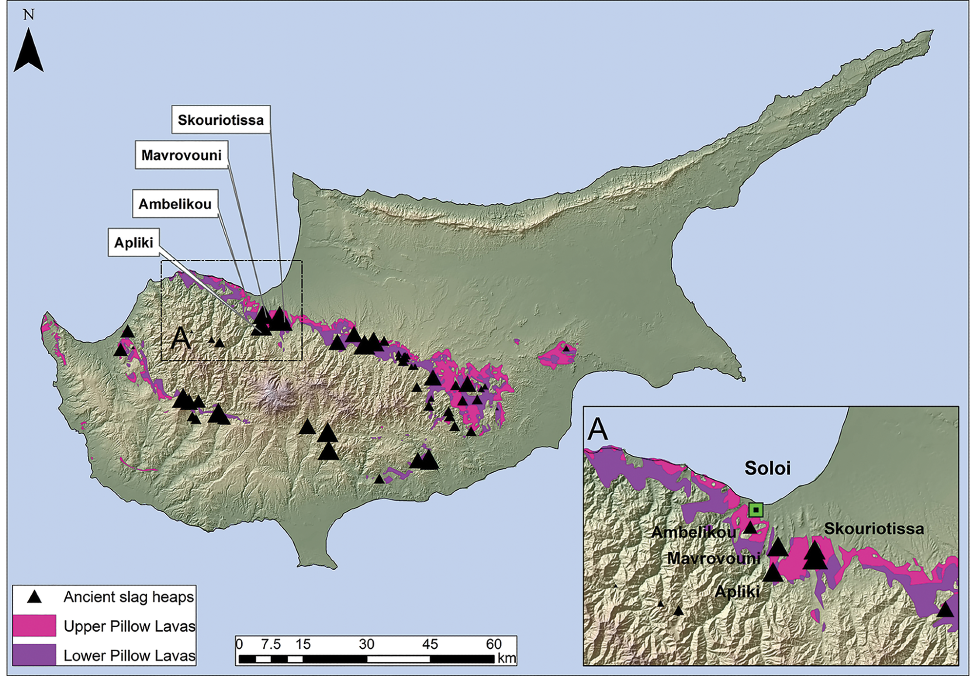
Figure 2. Map of Cyprus showing the Pillow Lava geological formation (where copper ore deposits are found), the location of the ancient slag heaps (triangles indicating size) and, inset, the area of the Solea mines. Image Credit: Map by A. Agapiou using digital geological data provided by the Cyprus Geological Survey.
Methodology
The copper ore deposits of Cyprus were largely untouched since ancient times and were of great interest to the British Empire. The Colonial Office commissioned a report in 1921 about the island’s cupriferous deposits. This report offers valuable information on the location of ancient mines and slag heaps in the foothills of the Troodos Mountains. After a millennium’s gap, Skouriotissa was the only active mine on the island in the 1920s.
Modern exploitation at the Skouriotissa ore deposit led to the discovery of ancient galleries and adits. Well-preserved ladders, wooden supports, ropes, and even baskets were found. Radiocarbon dating of the well-preserved wooden supports indicates that mining at Skouriotissa dates back to the ninth century BC.
A previous article reported three hand-drawn plans indicating the location of ancient underground workings with respect to the outline of the Skouriotissa orebody. The key to facilitating georeferencing of these plans is to create accurate topographic maps of Skouriotissa. The topographic maps include the location of all earlier drill holes and buildings associated with the mining company.
These buildings served as geospatial control points to rectify an older map of the region with the most recent high-resolution aerial orthophotograph taken in 2014. Figure 3 illustrates the result of the georeferencing performed.

Figure 3. 2014 aerial photograph with the location of mining adits and other places of interest indicated in Bruce and Cullis and Edge. Image Credit: Figure by A. Agapiou; photograph courtesy of the Republic of Cyprus’ Department of Lands and Surveys.
The slag heaps, dumps, and ancient adits—including the pottery assemblage (labeled as “ancient bottle (pottery) dump” on Figure 4)—and several other remains such as stone walls and features that were still visible in the 1960s were recorded with great accuracy by a previous study.
All such spatial information has been georeferenced and manually digitized (see Figure 4). The precise location of 319 tombs—an entire necropolis—was also recorded by the previous study. This study georeferenced and superimposed the location of the tombs in the 2014 aerial photograph (see Figure 4).
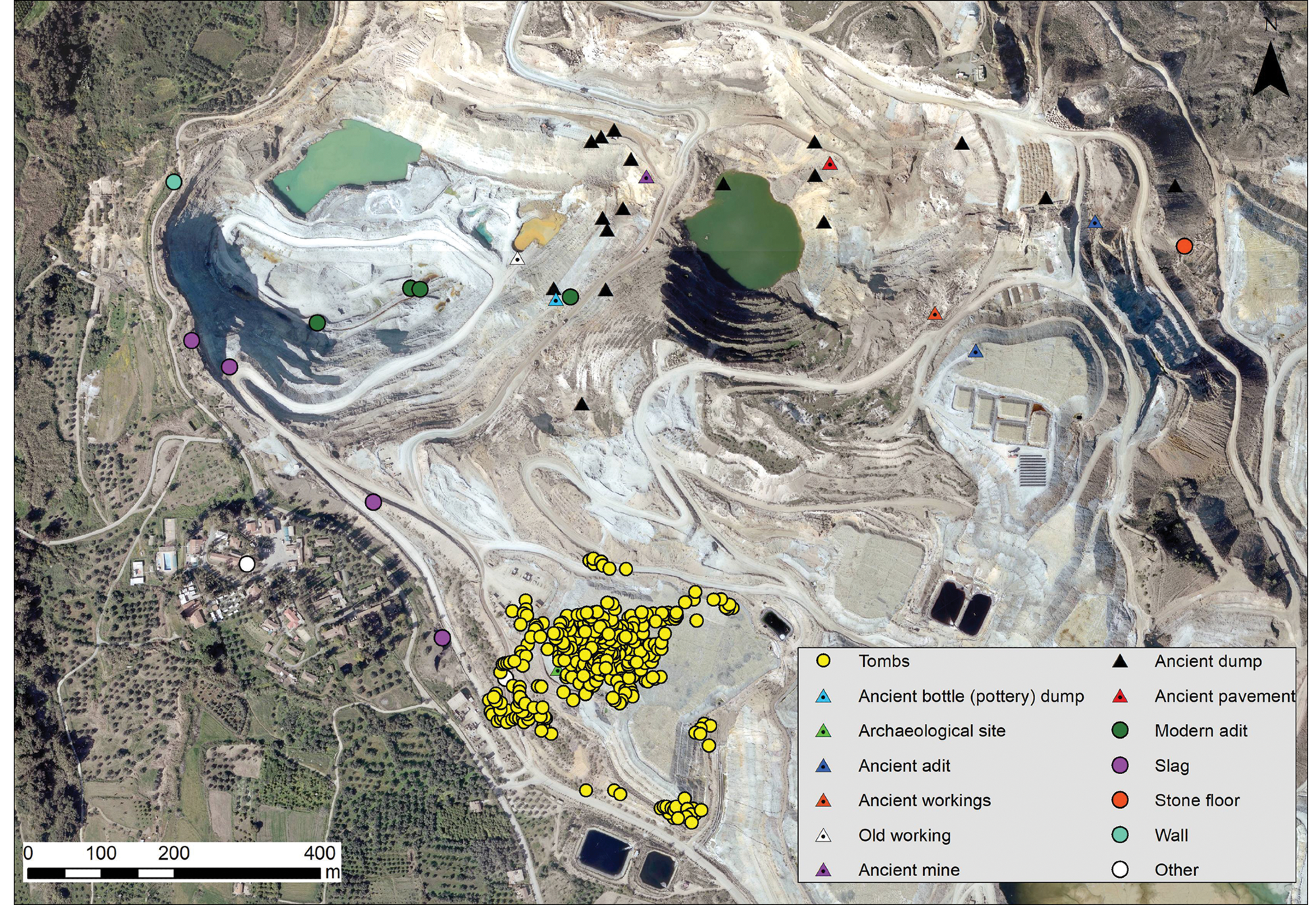
Figure 4. Places of archaeological interest noted on Kortan’s map, overlaid on the 2014 aerial photograph of the area of Skouriotissa. Image Credit: Figure by A. Agapiou; photograph courtesy of the Republic of Cyprus’ Department of Lands and Surveys.
The slag heaps are the most significant ancient anthropogenic landmarks in the Skouriotissa region (see Figures 5, 6, 7a, and 7b).
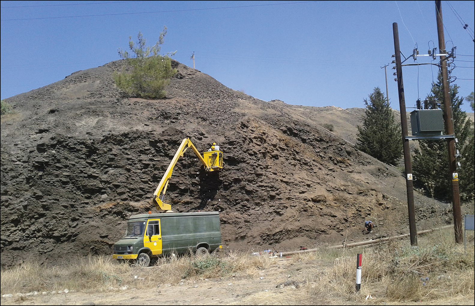
Figure 5. The Late Roman slag heap of Skouriotissa. Image Credit: Photograph by V. Kassianidou, taken in 2011.
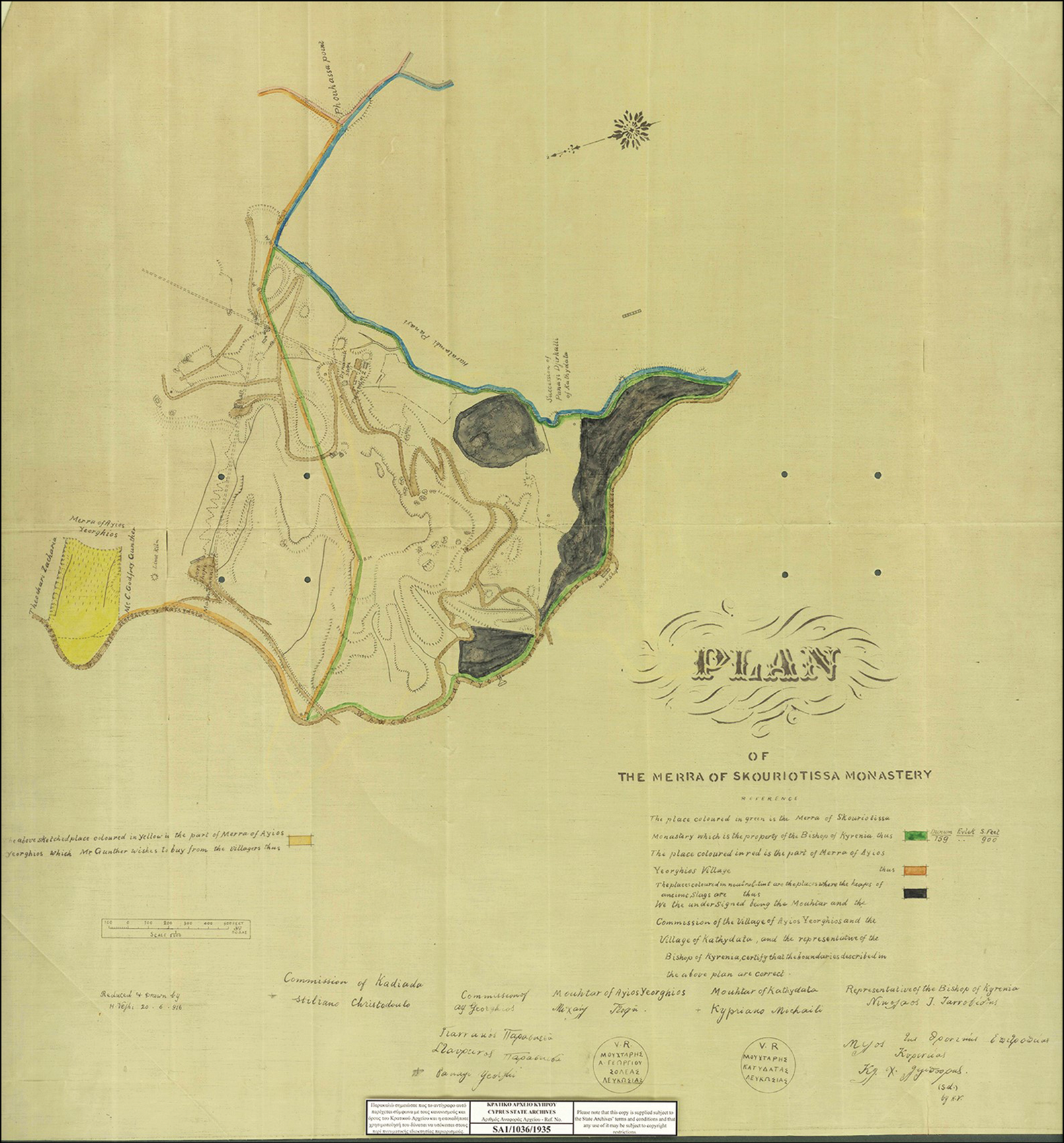
Figure 6. Map of the Merra of Skouriotissa Monastery showing the two slag heaps in 1916. Image Credit: Courtesy of the State Archives of Cyprus; SA1/1036/1915.
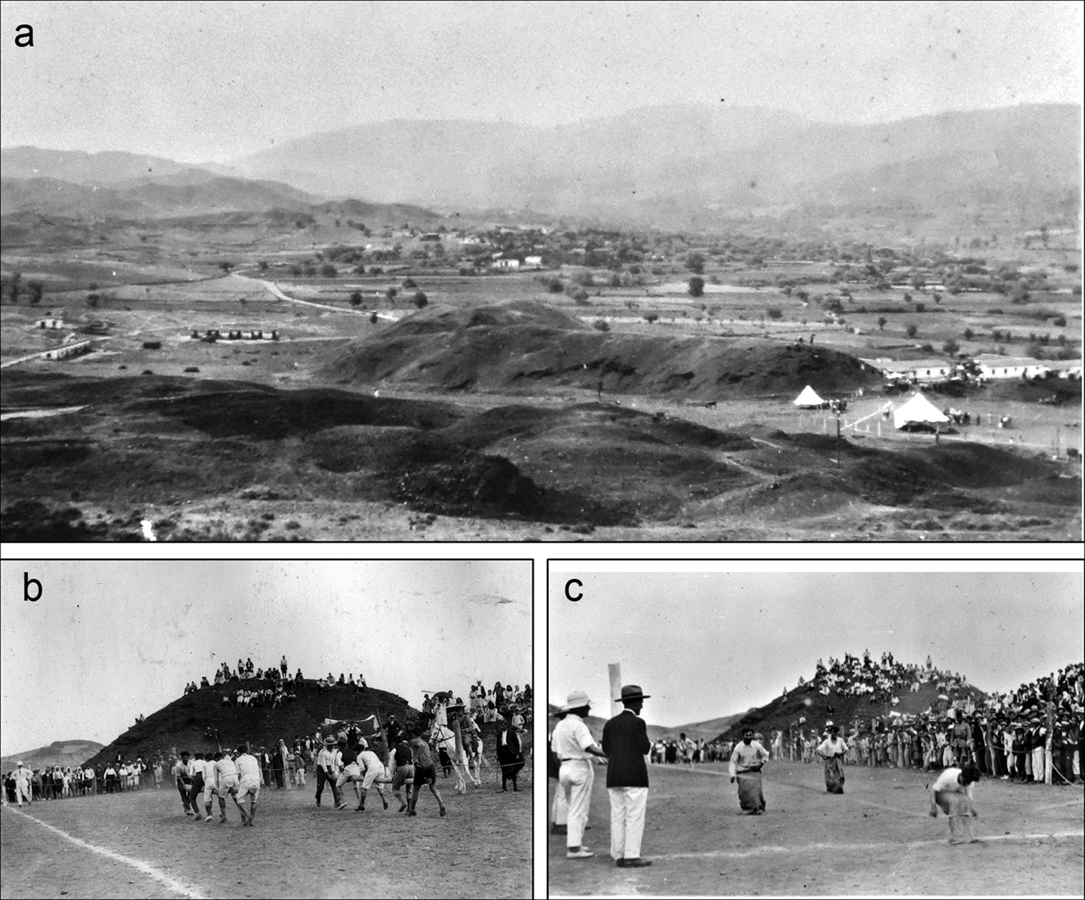
Figure 7. (a) The Skouriotissa slag heap in 1929; (b–c) sports day at Skouriotissa, March 1929. Image Credit: Photographs from the J.L. Bruce archive, courtesy of members of his family.
In the past two decades, the slag heap remains have been investigated systematically by two field projects that involved the authors of this study.
The two heaps can be clearly seen in a 1957 aerial photograph taken by the Department of Lands and Surveys (see Figure 8a). During that period, the mine was still running through underground galleries, and the topography of the region had not yet been modified much.
Open-cast mining advanced well by 1970, when another aerial photograph was captured, and large spoil heaps were created (see Figure 8b), completely covering the earlier (red) slag heap and considerably reducing the extent of the larger (black) slag heap.
The latest aerial photograph taken in 2014 by the Lands and Survey Department illustrates a totally modified industrial landscape, with the size of the larger (black) slag heap reduced considerably (see Figure 8c). The scale of destruction has been depicted by overlaying the slag heap outlines in 1950 and 1970 onto the 2014 photograph (see Figure 8d).
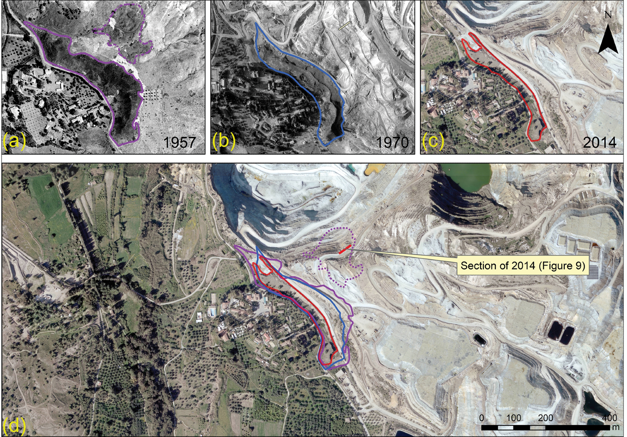
Figure 8. Collage of aerial photographs. The two slag heaps in (a) 1957; (b) 1970; (c) 2014; (d) combination of the outline of the slag heaps superimposed on the 2014 aerial photograph. Image Credit: Figure by A. Agapiou; 1957, 1970, and 2014 aerial photographs courtesy of the Republic of Cyprus’ Department of Lands and Surveys.
The main goal of this study is the absolute dating of the smelting activities and the slag heaps at Skouriotissa. A part of the road was removed using heavy equipment to reveal further lower levels. Photogrammetry was used to document the stratigraphy (see Figure 9).
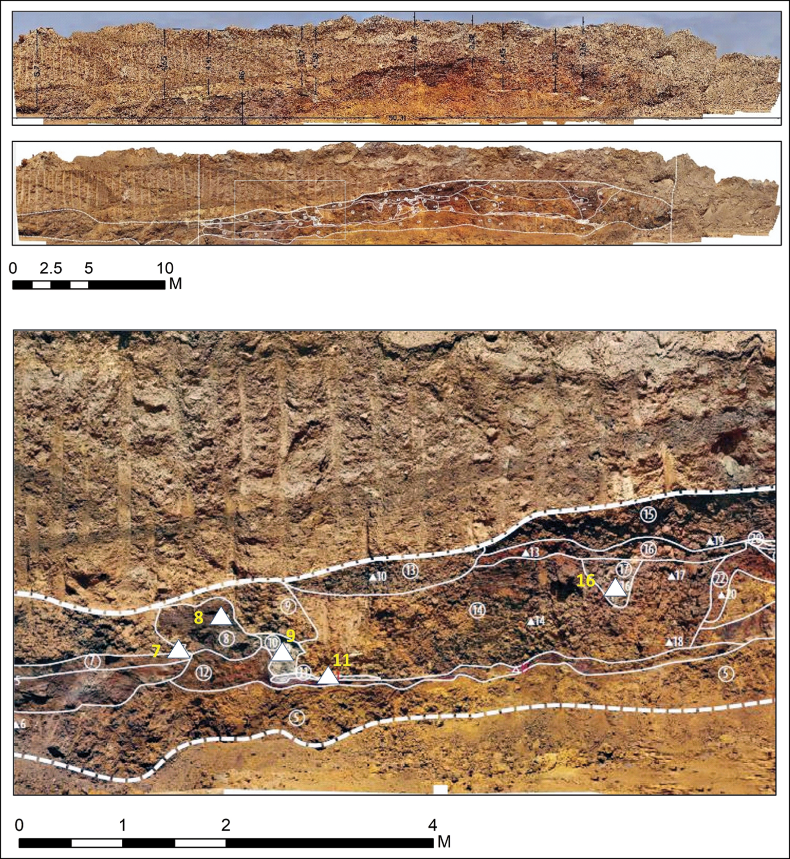
Figure 9. Section of the slag heap recorded in 2016, indicating the location of the samples used for radiocarbon dating (the location of the section is shown in Figure 8). Image Credit: Figure by A. Agapiou & A. Georgiadou.
In one part of the section (shown in the lower part of Figure 9; see also Figure 10), six charcoal samples (two pinecone scales and four wood or wood charcoal) were obtained from several layers. The radiocarbon dating results of these samples provide calibrated calendar dates between 172 BC and AD 21 (at a probability of 95.4%, using OxCal v4.4.1 and IntCal20; see Figure 10).
The dating places the activity either in the decades immediately before the annexation of Cyprus by Rome (from the Ptolemaic kingdom of Egypt) in 58 BC, or in the early decades of Roman control.
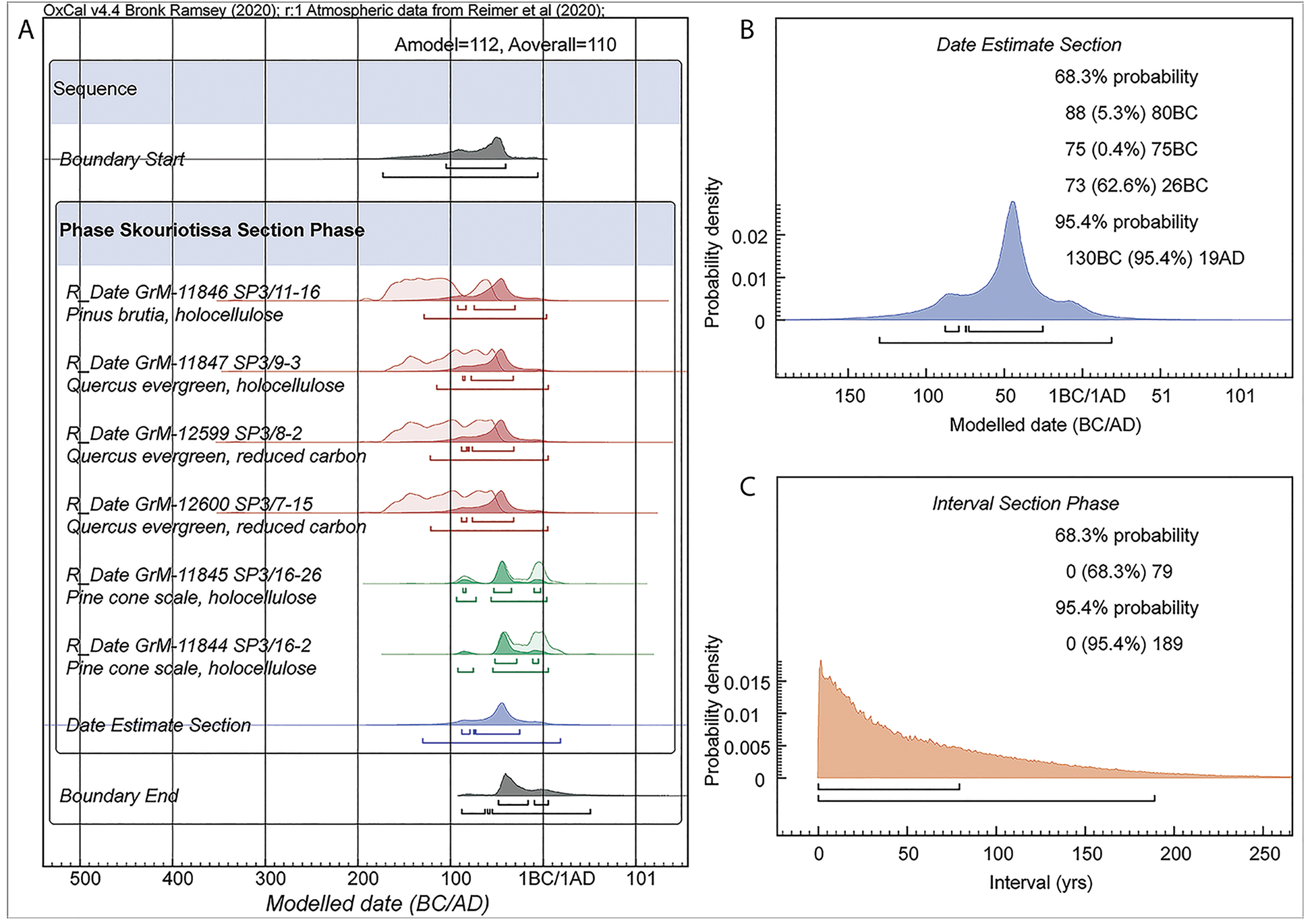
Figure 10. Radiocarbon dates from the slag heap section in Figure 9 using OxCal v4.4.1 and IntCal20: (A) the six dates modeled as a uniform probability phase. Dates in brown are on wood/charcoal and are assumed to include some in-built age (OxCal Charcoal Outlier model applied). Dates in green are on shorter-lived samples (pine cone scales) (OxCal General Outlier model applied). Light-shaded distributions indicate the non-modeled calibrated probabilities; dark distributions indicate the modeled posterior densities. The 68.3% and 95.4% ranges are indicated; (B) the date estimate query from A; (C) an interval query for the phase in A. Image Credit: Figure by S. Manning.
Conclusion
An analysis of different archaeological, historical, and topographical data allowed the reconstruction of Skouriotissa. Georeferencing helped reconstruct the location of ancient mining galleries and adits rediscovered and then destroyed by modern mining operations. The study results indicate that ancient mining focused on the ore deposit of Phoukasa.
Absolute dating of a newly unraveled section of a red slag heap between Phoukasa and the Late Roman slag heap illustrates that extensive copper production occurred during the Late Hellenistic period or the Early Roman period.
However, the most extensive exploitation of this rich copper deposit was found to be in the Late Roman/Early Byzantine period. An analysis of the historical aerial photographs helped trace the actual extent of the slag heaps and perform dating of part of the earlier red slag heap.
The location of an ancient amphora dump and that of a previously unknown necropolis were also recorded. Both of these are likely to date to the Roman to Late Roman/Early Byzantine periods. The successful combination of ancient archaeological, topographical, and historical data will form a pilot for gaining insights into other mining regions of Cyprus and beyond.
Journal Reference:
Kassianidou, V., Agapiou A., Manning, S. W. (2021) Reconstructing an ancient mining landscape: a multidisciplinary approach to copper mining at Skouriotissa, Cyprus. Antiquity, 95(382), pp. 986–1004. Available at: https://doi.org/10.15184/aqy.2021.33.
References and Further Reading
- Bachmann, H-G (1982) The identification of slags from archaeological sites (Institute of Archaeology Occasional Publication 6). London: Institute of Archaeology.
- Bear, L M (1963) The mineral resources and mining industry of Cyprus (Geological survey of Cyprus, Bulletin 1). Nicosia: Geological Survey Department, Ministry of Commerce and Industry.
- Ben-Yosef, E., et al. (2011) The Cyprus Archaeomagnetic Project (CAMP): targeting the slag deposits of Cyprus and the Eastern Mediterranean. Antiquity Project Gallery 85. Available at: https://www.antiquity.ac.uk/projgall/ben-yosef330/ (Accessed 3 March 2021).
- Bourgarit, D (2019) Mineralogy of slags: a key approach for our understanding of ancient copper smelting processes. EMU Notes in Mineralogy, 20, pp. 203–231. doi.org/10.1180/EMU-notes.20.5.
- Bronk Ramsey, C (2009a) Bayesian analysis of radiocarbon dates. Radiocarbon, 51, 337–360. doi.org/10.1017/S0033822200033865.
- Bronk Ramsey, C (2009b) Dealing with outliers and offsets in radiocarbon dating. Radiocarbon, 51, pp. 1023–1045. doi.org/10.1017/S0033822200034093.
- Bruce, J L (1937) Appendix V: antiquities in the mines of Cyprus. In: Gjerstad, E., et al. (Eds) The Swedish Cyprus Expedition: Finds and Results of the Excavations in Cyprus 1927–1931, Volume III, pp. 639–671. Stockholm: Swedish Cyprus Expedition.
- Constantinou, G (1982) Geological features and ancient exploitation of the cupriferous sulphide orebodies of Cyprus. In: Muhly, J.D., et al. (Eds) Early Metallurgy in Cyprus 4000–500 BC, pp. 13–23. Larnaca: Pierides Foundation.
- Constantinou, G (1992a) Ancient copper mining in Cyprus. In: Marangou, A & Psillides, K (Eds) Cyprus Copper and the Sea, pp. 44–75. Nicosia: Government of Cyprus.
- Constantinou, G (1992b) The mining industry of Cyprus in modern times. In: Marangou, A & Psillides, K (Eds) Cyprus Copper and the Sea, pp. 328–367. Nicosia: Government of Cyprus.
- Counts, D B & Iacovou, M (2013) New approaches to the elusive Iron Age polities of ancient Cyprus: an introduction. Bulletin of the American Schools of Oriental Research, 370, pp. 1–13. doi.org/10.5615/bullamerschoorie.370.0001.
- Cullis, C G (1924) A sketch of the geology and mineral resources of Cyprus. Journal of the Royal Society of Arts, 72, pp. 624–647.
- Cullis, C G & Edge, A B (1927) Report on the Cupriferous Deposits of Cyprus. London: Crown Agents for the Colonies.
- Davies, O (1928–1930) The copper mines of Cyprus. Annual of the British School at Athens, 30, pp. 74–85. doi.org/10.1017/S0068245400011497.
- Everett, W J (2017) Mining Memories on Cyprus 1923–1925: Photographs, Correspondence and Reflections. Kindle Edition.
- Given, M (2018) The materiality, monumentality and biography of copper slag on Cyprus. In: Nevett, L & Whitley, J (Eds) An Age of Experiment: Classical Archaeology Transformed (1976–2014), pp. 161–176. Cambridge: McDonald Institute for Archaeological Research.
- Given, M., et al. (2013) Landscape and Interaction: The Troodos Archaeological & Environmental Survey Project, Cyprus (volumes 1–2) (Levant Supplementary Series 14–15). Oxford: Council for British Research in the Levant & Oxbow.
- Healy, J F (1978) Mining and Metallurgy in the Greek and Roman World. London: Thames & Hudson.
- Ingham, F T (1959) Economic geology. In: Wilson, R A M (Ed.) The Geology of the Xeros-Troodos Area (Geological Survey Department Cyprus Memoir 1), pp. 137–177. Nicosia: Geological Survey Department.
- Jacobsen, K W (2007) Transport amphorae in the copper mining industry of Cyprus: introducing a new type of transport amphorae from Cyprus. In: Bonifay, M & Treglia, J-C (Eds) LRCW 2: Late Roman Coarse Wares, Cooking Wares and Amphorae in the Mediterranean: Archaeology and Archaeometry, volume II (British Archaeological Reports International Series 1662), pp. 775–779. Oxford: British Archaeological Reports.
- Kassianidou, V (2000) Hellenistic and Roman mining in Cyprus. In: Ioannides, G K & Hadjistyllis, S A (Eds) Acts of the Third International Congress of Cypriot Studies, Nicosia, 16–20 April 1996. Volume A: Ancient Section, pp. 745–756. Nicosia: Society of Cypriot Studies.
- Kassianidou, V (2004) Recording Cyprus’ mining history through archaeological survey. In: Iacovou, M (Ed.) Archaeological Field Survey in Cyprus: Past History, Future Potential. Proceedings of a conference held by the Archaeological Research Unit of the University of Cyprus, 1–2 December, 2000: pp. 95–104 (British School at Athens Studies 11). London: British School at Athens.
- Kassianidou, V (2013a) Ancient and modern copper production at Skouriotissa Vouppes. In: Given, M., et al. (Eds) Landscape and Interaction: The Troodos Archaeological & Environmental Survey Project, Cyprus (volume 2) (Levant Supplementary Series 14–15), pp. 114–138. Oxford: Council for British Research in the Levant & Oxbow.
- Kassianidou, V (2013b) The exploitation of the landscape: metal resources and the copper trade during the age of the Cypriot city-kingdoms. Bulletin of the American School of Oriental Research, 370, pp. 49–82. doi.org/10.5615/bullamerschoorie.370.0049.
- Kassianidou, V & Papasavvas, G (2012) Eastern Mediterranean metallurgy and metalwork in the second millennium BC: a conference in honour of James D. Muhly. Oxford: Oxbow. Available at: https://doi.org/10.2307/j.ctvh1dvpm.
- Kortan, O (1970) Zur Bildung der Schwefelkies-Kupferkies-Vorkommen Cyperns unter besonderer Berücksichtigung der Lagerstätte Skouriotissa. Unpublished PhD Dissertation, Technischen Universitat Clausthal.
- Lavender, D S (1962) The Story of the Cyprus Mines Corporation. Los Angeles (CA): Huntingdon Library.
- Manning, S W (2013) Absolute dating of charcoal samples from the slag heaps. In: Given, M., et al. (Eds) Landscape and Interaction: the Troodos Archaeological & Environmental Survey Project, Cyprus (volume 1) (Levant Supplementary Series 14), pp. 48–54. Oxford: Council for British Research in the Levant & Oxbow.
- Mehl, A (2009) Der Archäologe Ludwig Ross 1845 in Zypern auf den Spuren der Antike. In: Rogge, S (Ed.) Zypern und der Vordere Orient im 19. Jahrhundert: die Levante im Fokus von Politik und Wissenschaft der europäischen Staaten. Symposium, Münster 27–28. Oktober 2006, pp. 153–187. Munster: Waxmann.
- Muhly, J. D., et al. (Eds) (1982) Early Metallurgy in Cyprus 4000–500 BC. Larnaca: Pierides Foundation.
- O’Brien, W (2015) Prehistoric Copper Mining in Europe 5500–500 BC. Oxford: Oxford University Press.
- Prothero, G W (1920) Cyprus (Handbooks Prepared Under the Direction of the Historical Section of the Foreign Office 65). London: H.M. Stationery Office.
- Rawlinson, G (1889) History of Phoenicia. London: Longmans, Green & Co.
- Reimer, P. J., et al. (2020) The IntCal20 Northern Hemisphere radiocarbon age calibration curve (0–55 kcal BP). Radiocarbon, 62, pp. 725–757. doi.org/10.1017/RDC.2020.41.
- Ross, L (1852) Reise nach Kos, Halikarnassos, Rhodes und Cypern. Halle: CA Schwetschke & Sohn.
- Shaar, R., et al. (2015) Decadal-scale variations in geomagnetic field intensity from ancient Cypriot slag mounds. Geochemistry, Geophysics, Geosystems, 16, pp. 1–20. doi.org/10.1002/2014GC005455.
- Shirley, R (2001) Kitchener’s Survey of Cyprus 1878–1883: The First Full Triangulated Survey and Mapping of the Island. Nicosia: The Bank of Cyprus Cultural Foundation.
- Socratous, M. A., et al. (2015) Ancient slag heaps in Cyprus: the contribution of charcoal analysis to the study of the ancient copper industry. In: Hauptmann, A & Modarressi-Tehrani, D (Eds) Archaeometallurgy in Europe III: Proceedings of the Third International Conference, Deutsches Bergbau-Museum Bochum, June 29–July 1, 2011 (Der Anschnitt, Beiheft 26), pp. 377–384. Bochum: Deutches Bergbau Museum.
- Stöllner, T R (2014) Methods of mining archaeology (Montanarchäologie). In: Roberts, B W & Thornton, C P (Eds) Archaeometallurgy in Global Perspective, pp. 91–105. New York: Springer. Available at: https://doi.org/10.1007/978-1-4614-9017-3_7.
- Wallace, P W & Orphanides, A G (1990) Sources for the History of Cyprus. Volume I: Greek and Latin Texts to the Third Century AD. Albany (NY): The Institute of Cypriot Studies, University at Albany, State University of New York & Cyprus College.