Rabun County in Georgia is a treasure trove for waterfall hunters. Some of these falls are easy to visit, while a few others require more effort. Bad Branch Falls requires more effort, at least to get there in the first place. The journey involves driving 6 miles down the paved, but very curvy and winding, Lake Rabun Road. Then there is another 3 mile drive down a curvy, winding, unpaved road. The unpaved road was by no means dangerous, but it can be tiresome. It’s out there in relative isolation, and I had lingering thoughts of cars breaking down.
Not to deter anyone from visiting Bad Branch Falls, but to further complicate things, there aren’t any clear signs for the falls along this road. Lower and Upper Crow Creek Falls are both found further along the road. The only way to identify that trail is by intently looking for a small creek. In the case of Bad Branch Falls, the falls if further back, so it is much easier to miss the creek area. (And the unmarked trailhead might not be right where the creek is found, if I remember correctly). I honestly think it was pure chance that I seemed to notice a trail heading slightly uphill, and only after driving by it two or three times. (Turning around along the narrow, curving, road was another stress-inducer.) In the end, it helps to set the odometer, and pay attention like a hawk for the not-very-noticeable trail!
If you can find the trail to the falls, you’re in for a treat. I find Bad Branch Falls to be particularly beautiful. There is something about the slanted rock formation that is very intriguing to me. The water cascades down it in a unique fashion. I wasn’t as impressed by the falls on Crow Creek, so I was glad when I found this taller falls nearby. It’s definitely worth a visit if you’re willing to just let your worries go away and enjoy the journey.
Directions:
- You’ll be travelling along US-441 north of Tallulah Falls.
- About 2 miles north of Tallulah Falls will be Old US-441.
- Turn onto old US-441, heading west for about 2.5 miles.
- Turn left on Lake Rabun Rd. and go for 6 miles. You will come to a dam with a road that crosses the lake/river right before the dam.
- Turn left and cross the dam.
- Go a short distance and turn/veer right onto Crow Creek Rd.
- Start watching your odometer. Travel for 2.9 miles on Crow Creek Rd. It will be rather narrow at points, so be careful!
- Right around the 2.8 mile mark, start paying attention for a trail that will be on your left. It will be unmarked, and if I remember correctly, it seems to climb uphill. The only way it is really noticeable is that the trail is at least moderately worn.
- I don’t remember if there was an official place to park. There might have been a make-shift pullout right near the trailhead, though I have a feeling I just tried to pull over as much as possible. While the road is narrow, it is not very busy, at least not in early March. (A recreation area with restrooms might be just past the trailhead, so pay attention to that as another possible point to help you find the falls.)
- After finding the trailhead, it’s a rather short hike to the falls.
- The falls on Crow Creek are just 0.8 miles further down the road. You might be able to use them as a basis for finding Bad Branch Falls, as the falls on Crow Creek are easier to find.
Accessibility: 9/10 (easy)
Height: 30′
Length of Hike: 0.4 miles round-trip
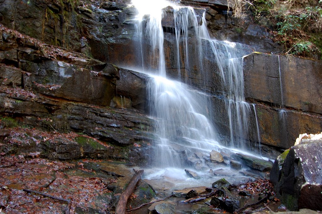
Bad Branch Falls in March 2009
Where in the World is Bad Branch Falls?

It is near minehaha falls then! Cool!
Yep, it’s not too far from Minnehaha Falls!
If you are at all into rock climbing proceed upstream from this pictured falls. There are 2 more even more spectacular falls upstream from Bad Branch falls. It is slippery and strenuous however. Coming down is harder than going up. Circle around to the left of the falls to get upstream.