Download presentation
Presentation is loading. Please wait.

1
Southern & Eastern Asia
Directions: Label the following countries on the political map of SE Asia: China India Japan North Korea South Korea Vietnam Map Key

2
Southern & Eastern Asia
Directions: 1. Label the following physical features: Ganges River Huang He (Yellow River) Chang Jiang (Yangtze) River Bay of Bengal Indian Ocean Sea of Japan South China Sea Yellow Sea Gobi Desert Taklimakan Desert Himalayan Mountains Korean Peninsula 2. Create a map key that includes symbols for: Rivers Mountains Deserts Bays Seas Oceans Peninsulas 3. Draw the symbol for each feature next to the correct label on the map. Color all symbols! Map Key
 Chang Jiang (Yangtze) River. Bay of Bengal. Indian Ocean. Sea of Japan. South China Sea. Yellow Sea. Gobi Desert. Taklimakan Desert. Himalayan Mountains. Korean Peninsula. 2. Create a map key that includes symbols for: Rivers. Mountains. Deserts. Bays. Seas. Oceans. Peninsulas. 3. Draw the symbol for each feature next to the correct label on the map. Color all symbols! Map Key.")
3
Southern & Eastern Asia KEY
Directions: 1. Label the following countries on the political map of Asia: China North Korea India South Korea Vietnam Japan North Korea South Korea Japan China India Map Key Vietnam

4
Southern & Eastern Asia KEY
Directions: 1. Label the following physical features: Ganges River Huang He (Yellow River) Chang Jiang (Yangtze) River Bay of Bengal Indian Ocean Sea of Japan South China Sea Yellow Sea Gobi Desert Taklimakan Desert Himalayan Mountains Korean Peninsula 2. Create a map key that includes symbols for: Rivers Mountains Deserts Bays Seas Oceans Peninsulas 3. Draw the symbol for each feature next to the correct label on the map. Color all symbols! Gobi Desert Taklimakan Desert Huang He (Yellow) River Sea of Japan Korean Peninsula Himalayan Mountains Yellow Sea Ganges River Chang Jiang (Yangtze) River South China Sea Bay of Bengal Map Key
 Chang Jiang (Yangtze) River. Bay of Bengal. Indian Ocean. Sea of Japan. South China Sea. Yellow Sea. Gobi Desert. Taklimakan Desert. Himalayan Mountains. Korean Peninsula. 2. Create a map key that includes symbols for: Rivers. Mountains. Deserts. Bays. Seas. Oceans. Peninsulas. 3. Draw the symbol for each feature next to the correct label on the map. Color all symbols! Gobi Desert. Taklimakan Desert. Huang He (Yellow) River. Sea of. Japan. Korean. Peninsula. Himalayan Mountains. Yellow. Sea. Ganges. River. Chang Jiang (Yangtze) River. South China Sea. Bay of Bengal. Map Key.")
5
SE Asia’s Geography CLOZE Notes 1
Chang Jiang (Yangtze) River Huang He (Yellow River) Ganges River Geography Some parts were built over 2,000 years ago. The Chang Jiang and Huang He Rivers are connected by one of the world’s oldest canal systems, the Grand Canal. The Chang Jiang is extremely important for China because it provides hydroelectric power, water for irrigation, and transportation for cargo ships. The Chang Jiang empties into the Pacific Ocean. It’s the largest and longest river in China (over 3,400 miles) and the third-longest in the world. The Chang Jiang (Yangtze) River begins in the Tibetan Plateau and travels east until it reaches the East China Sea. It’s nickname is “China’s Sorrow” because of the frequent flooding. The silt creates rich topsoil for farmers; however, annual floods make the river’s path dangerous. The river is named for the muddy yellow silt that it carries along its path to the Yellow Sea. Chinese civilization began in the central area of this river basin. This is China’s second-longest river. The Huang He, or Yellow River, begins in the mountainous plateau of Tibet and flows east to the Yellow Sea. Because so many people live and work along the Ganges, the water in the river is heavily polluted. The river runs through India’s most fertile farmland and densely populated areas. It is the most important river to the Indian subcontinent. The name comes from a Hindu goddess and the river is considered sacred to the Hindu religion. The Ganges River starts in the Himalayas and flows southeast through India and Bangladesh for more than 1,500 miles to the Indian Ocean. The continent has a wide variety of physical features, including deserts, peninsulas, and the world’s highest mountains. More than 4 billion people live in Southern and Eastern Asia, with over half of that number living in China and India alone. Asia is the world’s largest continent with a total land area of more than 17 million square miles. SE Asia’s Geography CLOZE Notes 1
 River. Huang He (Yellow River) Ganges River. Geography. Some parts were built over 2,000 years ago. The Chang Jiang and Huang He Rivers are connected by one of the world’s oldest canal systems, the Grand Canal. The Chang Jiang is extremely important for China because it provides hydroelectric power, water for irrigation, and transportation for cargo ships. The Chang Jiang empties into the Pacific Ocean. It’s the largest and longest river in China (over 3,400 miles) and the third-longest in the world. The Chang Jiang (Yangtze) River begins in the Tibetan Plateau and travels east until it reaches the East China Sea. It’s nickname is China’s Sorrow because of the frequent flooding. The silt creates rich topsoil for farmers; however, annual floods make the river’s path dangerous. The river is named for the muddy yellow silt that it carries along its path to the Yellow Sea. Chinese civilization began in the central area of this river basin. This is China’s second-longest river. The Huang He, or Yellow River, begins in the mountainous plateau of Tibet and flows east to the Yellow Sea. Because so many people live and work along the Ganges, the water in the river is heavily polluted. The river runs through India’s most fertile farmland and densely populated areas. It is the most important river to the Indian subcontinent. The name comes from a Hindu goddess and the river is considered sacred to the Hindu religion. The Ganges River starts in the Himalayas and flows southeast through India and Bangladesh for more than 1,500 miles to the Indian Ocean. The continent has a wide variety of physical features, including deserts, peninsulas, and the world’s highest mountains. More than 4 billion people live in Southern and Eastern Asia, with over half of that number living in China and India alone. Asia is the world’s largest continent with a total land area of more than 17 million square miles. SE Asia’s Geography. CLOZE Notes 1.")
6
SE Asia’s Geography CLOZE Notes 2
Yellow Sea South China Sea Sea of Japan Indian Ocean Bay of Bengal Unfortunately, in recent years, many species of fish have declined in the Yellow Sea due to overfishing by some countries. The Yellow Sea is well-known for its fishing industry. It becomes the East China Sea south of the Korean Peninsula. The Huang He (Yellow River) empties into the Yellow Sea. The Yellow Sea is an extension of the Pacific Ocean that lies between China and the Korean Peninsula. There are often violent monsoons and typhoons in this region. The South China Sea connects the Pacific and Indian oceans, so many of the world’s international shipping channels run through it. The South China sea is located between Vietnam and the Philippines. The sea has large deposits of mineral resources and abundant fish, both of which are important to Japan’s economy. It is an arm of the Pacific Ocean that lies between the Asian continent and Japan. The Sea of Japan is a small sea that is bound by Russia to the north, the Korean Peninsula to the west, and Japan to the east. It is located between Africa to the west, Asia to the north, and Australia to the east. The Indian Ocean is the third largest of Earth’s five oceans. The Ganges and many other large rivers flow into this bay. The Bay of Bengal touches India on its west and Myanmar on its east. The Bay of Bengal is an extension of the Indian Ocean. SE Asia’s Geography CLOZE Notes 2
 empties into the Yellow Sea. The Yellow Sea is an extension of the Pacific Ocean that lies between China and the Korean Peninsula. There are often violent monsoons and typhoons in this region. The South China Sea connects the Pacific and Indian oceans, so many of the world’s international shipping channels run through it. The South China sea is located between Vietnam and the Philippines. The sea has large deposits of mineral resources and abundant fish, both of which are important to Japan’s economy. It is an arm of the Pacific Ocean that lies between the Asian continent and Japan. The Sea of Japan is a small sea that is bound by Russia to the north, the Korean Peninsula to the west, and Japan to the east. It is located between Africa to the west, Asia to the north, and Australia to the east. The Indian Ocean is the third largest of Earth’s five oceans. The Ganges and many other large rivers flow into this bay. The Bay of Bengal touches India on its west and Myanmar on its east. The Bay of Bengal is an extension of the Indian Ocean. SE Asia’s Geography. CLOZE Notes 2.")
7
SE Asia’s Geography CLOZE Notes 3
Korean Peninsula Himalayan Mountains Taklimakan Desert Gobi Desert Since the end of World War II in 1948, the peninsula has been divided into two countries: North Korea (communist) and South Korea (democratic). Over half of the peninsula is made up of mountains, but there is still plenty of rich farmland. The Korean Peninsula is a mountainous peninsula that juts out of northeastern China in between the Yellow Sea and the Sea of Japan. Mt. Everest, the world’s highest mountain, is part of the Himalayan range. Nine of the world’s ten largest peaks are located here. It is sometimes called “the roof of the world” because of the area’s high altitudes. The Himalayan mountain range is the world’s highest mountain region. The mountains stretch for about 200 miles. They form the natural border between India and China. The Himalayas lie along the northern edge of the Indian subcontinent and the southern border of China. The plant and animal life in this desert have had to adapt to the dry environment in order to survive. The Taklimakan Desert receives very little annual precipitation. Giant sand dunes cover 85% of its surface. It is over 600 miles in length, making it one of the longest deserts in the world. The Taklimakan Desert lies between two rugged mountain ranges in northwestern China. It can be one of the hottest and also one of the coldest places on earth. The Gobi Desert is known as “Shamo”, the Chinese word for “sand desert”. Much of the Gobi Desert is covered with sand and bare rock that is exposed by powerful winds blowing across the region. It expands across southern Mongolia and northern China. The Gobi Desert is Asia’s largest desert. SE Asia’s Geography CLOZE Notes 3
 and South Korea (democratic). Over half of the peninsula is made up of mountains, but there is still plenty of rich farmland. The Korean Peninsula is a mountainous peninsula that juts out of northeastern China in between the Yellow Sea and the Sea of Japan. Mt. Everest, the world’s highest mountain, is part of the Himalayan range. Nine of the world’s ten largest peaks are located here. It is sometimes called the roof of the world because of the area’s high altitudes. The Himalayan mountain range is the world’s highest mountain region. The mountains stretch for about 200 miles. They form the natural border between India and China. The Himalayas lie along the northern edge of the Indian subcontinent and the southern border of China. The plant and animal life in this desert have had to adapt to the dry environment in order to survive. The Taklimakan Desert receives very little annual precipitation. Giant sand dunes cover 85% of its surface. It is over 600 miles in length, making it one of the longest deserts in the world. The Taklimakan Desert lies between two rugged mountain ranges in northwestern China. It can be one of the hottest and also one of the coldest places on earth. The Gobi Desert is known as Shamo , the Chinese word for sand desert . Much of the Gobi Desert is covered with sand and bare rock that is exposed by powerful winds blowing across the region. It expands across southern Mongolia and northern China. The Gobi Desert is Asia’s largest desert. SE Asia’s Geography. CLOZE Notes 3.")
8
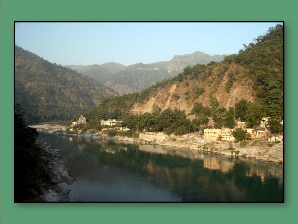
Ganges River The Ganges River starts in the Himalayas and flows southeast through India and Bangladesh for more than 1,500 miles to the Indian Ocean. The name comes from a Hindu goddess and the river is considered sacred to the Hindu religion. It is the most important river to the Indian subcontinent.

11
Ganges River The river runs through India’s most fertile farmland and densely populated areas. Because so many people live and work along the Ganges, the water in the river is heavily polluted.

13
Huang He (Yellow River)
The Huang He, or Yellow River, begins in the mountainous plateau of Tibet and flows east to the Yellow Sea. This is China’s second-longest river. Chinese civilization began in the central area of this river basin.

16
Huang He (Yellow River)
The river is named for the muddy yellow silt that it carries along its path to the Yellow Sea. The silt creates rich topsoil for farmers; however, annual floods make the river’s path dangerous. It’s nickname is “China’s Sorrow” because of the frequent flooding.

18
Chang Jiang (Yangtze) River
The Chang Jiang (Yangtze) River begins in the Tibetan Plateau and travels east until it reaches the East China Sea. It’s the largest and longest river in China (over 3,400 miles) and the third-longest in the world. The Chang Jiang empties into the Pacific Ocean.
 River begins in the Tibetan Plateau and travels east until it reaches the East China Sea. It’s the largest and longest river in China (over 3,400 miles) and the third-longest in the world. The Chang Jiang empties into the Pacific Ocean.")
21
Chang Jiang (Yangtze) River
The Chang Jiang is extremely important for China because it provides hydroelectric power, water for irrigation, and transportation for cargo ships. The Chang Jiang and Huang He Rivers are connected by one of the world’s oldest canal systems, the Grand Canal. Some parts were built over 2,000 years ago.

22
© Brain Wrinkles

23
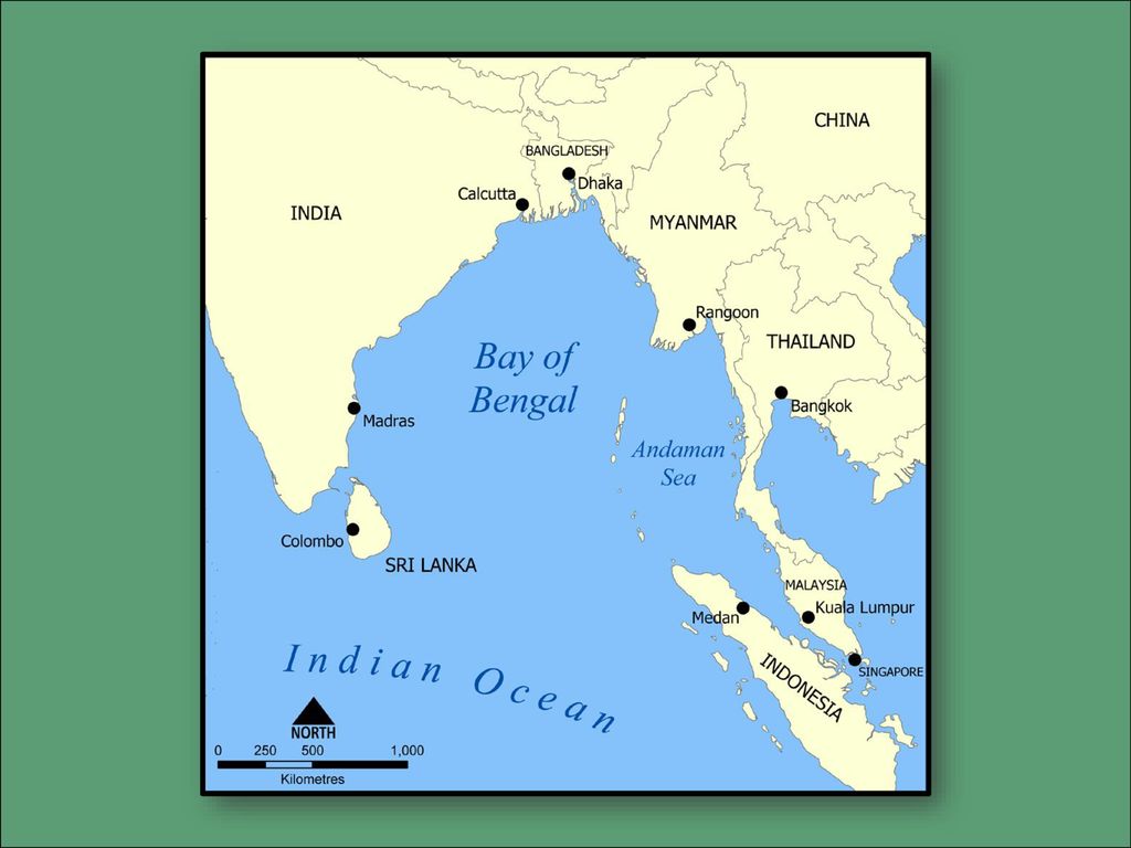
Bay of Bengal The Bay of Bengal is an extension of the Indian Ocean.
The Bay of Bengal touches India on its west and Myanmar on its east. The Ganges and many other large rivers flow into this bay.

27
Indian Ocean The Indian Ocean is the third largest of Earth’s five oceans. It is located between Africa to the west, Asia to the north, and Australia to the east.

29
Sea of Japan The Sea of Japan is a small sea that is bound by Russia to the north, the Korean Peninsula to the west, and Japan to the east. It is an arm of the Pacific Ocean that lies between the Asian continent and Japan. The sea has large deposits of mineral resources and abundant fish, both of which are important to Japan’s economy.

30
© Brain Wrinkles

32
South China Sea The South China sea is located between Vietnam and the Philippines. The South China Sea connects the Pacific and Indian oceans, so many of the world’s international shipping channels run through it. There are often violent monsoons and typhoons in this region.

35
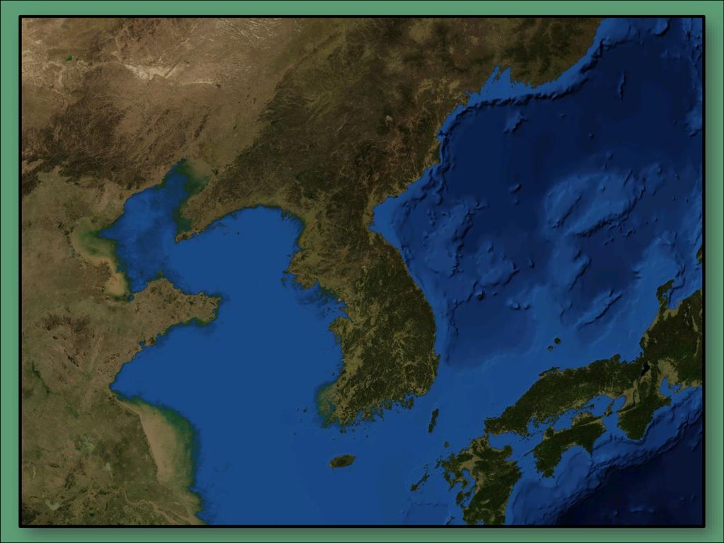
Yellow Sea The Yellow Sea is an extension of the Pacific Ocean that lies between China and the Korean Peninsula. The Huang He (Yellow River) empties into the Yellow Sea. It becomes the East China Sea south of the Korean Peninsula.
 empties into the Yellow Sea. It becomes the East China Sea south of the Korean Peninsula.")
37
Yellow Sea The Yellow Sea is well-known for its fishing industry.
Unfortunately, in recent years, many species of fish have declined in the Yellow Sea due to overfishing by some countries.

39
Gobi Desert The Gobi Desert is Asia’s largest desert.
It expands across southern Mongolia and northern China. Much of the Gobi Desert is covered with sand and bare rock that is exposed by powerful winds blowing across the region.

42
Gobi Desert The Gobi Desert is known as “Shamo”, the Chinese word for “sand desert”. It can be one of the hottest and also one of the coldest places on earth.

44
Taklimakan Desert The Taklimakan Desert lies between two rugged mountain ranges in northwestern China. It is over 600 miles in length, making it one of the longest deserts in the world. Giant sand dunes cover 85% of its surface.

46
© Brain Wrinkles

47
Taklimakan Desert The Taklimakan Desert receives very little annual precipitation. The plant and animal life in this desert have had to adapt to the dry environment in order to survive.

49
Himalayan Mountains The Himalayas lie along the northern edge of the Indian subcontinent and the southern border of China. They form the natural border between India and China. The mountains stretch for about 200 miles.

52
Himalayan Mountains The Himalayan mountain range is the world’s highest mountain region. It is sometimes called “the roof of the world” because of the area’s high altitudes.

54
Himalayan Mountains Nine of the world’s ten largest peaks are located here. Mt. Everest, the world’s highest mountain, is part of the Himalayan range.

56
Korean Peninsula The Korean Peninsula is a mountainous peninsula that juts out of northeastern China in between the Yellow Sea and the Sea of Japan. Over half of the peninsula is made up of mountains, but there is still plenty of rich farmland.

58
Korean Peninsula Since the end of World War II in 1948, the peninsula has been divided into two countries: North Korea (communist) and South Korea (democratic).
 and South Korea (democratic).")
60
SE Asia’s Physical Features
What: Where: Illustration: What: Where: Illustration: What: Where: Illustration: Indian Ocean Ganges River Chang Jiang (Yangtze) River Directions: Complete the chart below with information that you learn during the presentation. If time allows, color your illustrations. SE Asia’s Physical Features What: Where: Illustration: What: Where: Illustration: What: Where: Illustration: Sea of Japan Bay of Bengal Huang He (Yellow River)
 River. Directions: Complete the chart below with information that you learn during the presentation. If time allows, color your illustrations. SE Asia’s Physical Features. What: Where: Illustration: What: Where: Illustration: What: Where: Illustration: Sea of Japan. Bay of Bengal. Huang He (Yellow River)")
61
SE Asia’s Physical Features
What: Where: Illustration: What: Where: Illustration: What: Where: Illustration: Himalayan Mountains South China Sea Gobi Desert Directions: Complete the chart below with information that you learn during the presentation. If time allows, color your illustrations. SE Asia’s Physical Features What: Where: Illustration: What: Where: Illustration: What: Where: Illustration: Korean Peninsula Taklimakan Desert Yellow Sea

62
Key Vocabulary - KEY Ganges River
Provides water to India’s most fertile farmland and populated areas; sacred to Hindu religion Huang He (Yellow River) In northern China; muddy yellow silt; empties into Yellow Sea Chang Jiang (Yangtze) River Largest and longest river in China; important for hydroelectric power, irrigation, transportation Bay of Bengal Between India and Myanmar & Thailand; arm of the Indian Ocean Indian Ocean Third largest ocean; located between Africa to the west, Asia to the north, and Australia to the east Sea of Japan Lies between Asia and Japan; lots of fish and mineral resources South China Sea Lies between Vietnam and Philippines; connects the Pacific and Indian oceans; important for international shipping Yellow Sea Lies between China and Korean Peninsula; famous for fishing industry Gobi Desert Asia’s largest desert; stretches across Mongolia and northern China; mostly bare rock; has strong winds Taklimakan Desert Northwestern China; lies between 2 mountain ranges; large sand dunes; very dry with little rainfall Himalayan Mountains World’s tallest mountains; forms natural border between China and India; Mt. Everest Korea Peninsula Juts out of northeast China between Yellow Sea and Sea of Japan; 2 countries—North and South Korea
 In northern China; muddy yellow silt; empties into Yellow Sea. Chang Jiang (Yangtze) River. Largest and longest river in China; important for hydroelectric power, irrigation, transportation. Bay of Bengal. Between India and Myanmar & Thailand; arm of the Indian Ocean. Indian Ocean. Third largest ocean; located between Africa to the west, Asia to the north, and Australia to the east. Sea of Japan. Lies between Asia and Japan; lots of fish and mineral resources. South China Sea. Lies between Vietnam and Philippines; connects the Pacific and Indian oceans; important for international shipping. Yellow Sea. Lies between China and Korean Peninsula; famous for fishing industry. Gobi Desert. Asia’s largest desert; stretches across Mongolia and northern China; mostly bare rock; has strong winds. Taklimakan Desert. Northwestern China; lies between 2 mountain ranges; large sand dunes; very dry with little rainfall. Himalayan Mountains. World’s tallest mountains; forms natural border between China and India; Mt. Everest. Korea Peninsula. Juts out of northeast China between Yellow Sea and Sea of Japan; 2 countries—North and South Korea.")
63
Southern & Eastern Asia

Similar presentations


 FSMS Standard SS7G9.a Standard SS7G9.a Days 1-3 Days 1-3.>")

 FSMS Standard SS7G9.a>")

 Largest Mountain chain in the world.>")

 FSMS Standard SS7G9.a>")