Download presentation
Presentation is loading. Please wait.

1
12 River Systems Eric Christiansen Geology 111

3
River Systems River Systems River Erosion River Deposition Floods
Climate, Plate Tectonics and Rivers

4
Significance of Running Water
Running water is the major agent of erosion Stream networks dominate the Earth’s surface Humid as well as arid environments Most significant landform AS

5
Stream networks dominate the surface

6
River Systems A river or stream is any body of water that is flowing downhill in a well defined channel River systems consist of a main channel and all its tributaries

7
River Systems Drainage basin Drainage divide
The area of land that is drained by a certain river drainage system All the water in that area eventually finds its way into one of the rivers in the system Drainage divide Boundaries that separate one drainage basin from another

8
River Systems Collecting system Transporting system Dispersing system

9
Collecting Systems Headwaters of river system Network of tributaries
Funnel water into main stream Forms a drainage pattern

10
Transporting Systems Main trunk stream
Takes water and sediment from the collecting system and moves it to the ocean Collects additional water and sediment load Erosion and deposition of sediment both occur

11
Dispersing System Network of distributaries
Disperses water and sediment load Flows into ocean, lake or dry basin Sediment load is size separated in this system

12
Stream System Order A stream is part of a larger system
Mathematical ratios characterize the size and gradient of streams within a system Number of tributaries decreases downstream Tributary length increases downstream Gradient decreases downstream Channels are wider and deeper downstream

13
Stream Flow Dynamics Factors affecting stream behavior Discharge (Q)
Gradient Average velocity (V) Load Base level
 Load. Base level.")
14
Stream Flow Dynamics Discharge
The volume of water flowing past a given point in the river Discharge will vary with time and weather conditions Measured in cubic meters per second 1 m3 = 1000 L ~ 264 gallons

15
Stream Flow Dynamics Gradient
How steep is the slope of the stream channel Change in elevation divided by the distance traveled (m/km) Longitudinal profile is a concave upward Steep at headwaters Nearly flat at discharge area Gradient varies directly with stream velocity
 Longitudinal profile is a concave upward. Steep at headwaters. Nearly flat at discharge area. Gradient varies directly with stream velocity.")
16
Stream Flow Dynamics Velocity varies within the channel
Highest velocity is in the center of the channel, slightly below the surface Drag causes water to slow along the bottom, banks, and top Curved channel – velocity high on outside and lower on inside of bend

17
Stream Flow Dynamics Stream water velocity determines the type of flow found in the stream Low flow velocities - laminar flow, more common in more viscous fluids High flow velocities - turbulent flow Turbulent flow helps keep small particles suspended in the water column

18
Stream Flow Dynamics Load = Material carried by the stream
Suspended load (fine particles) or Bed load (coarse particles) Dissolved load (ions in solution)
 or. Bed load (coarse particles) Dissolved load (ions in solution)")
19
Stream Flow Dynamics Suspended Load - fine particles carried long distances suspended in the stream water Carried along at approximately the same rate as the stream water velocity Usually the largest fraction of transported sediment

20
Stream Flow Bed Load - particles moved along the stream bed by rolling, sliding, or saltation Saltation involves coarse particles jumping forward Bed load moves slower than water velocity Velocity controls the grain size of the bed load

21
Relationship between flow velocity & sediment transport

22
Stream Flow Dynamics Cations - Ca+2, Na+1, Mg+2, K+1
Dissolved Load is a product of chemical weathering Primarily composed of seven common ions Cations - Ca+2, Na+1, Mg+2, K+1 Anions - HCO3-1, SO4-2, Cl-1 Streams that receive large amounts of groundwater have higher dissolved loads Streams that receive mostly surface run-off have lower dissolved loads For Mississippi River, the dissolved load is about 30% of the total load

23
Stream Flow Dynamics Base Level - level to which a stream will erode
Velocity of stream decreases as it approaches base level Energy to erode decreases with stream velocity Base level represented by large bodies of water Sea Level - ultimate base level Lakes & Reservoirs - local base level

24
Equilibrium Gradients
Graded stream - a stream that is balanced between water flow, and sediment erosion and deposition Changes in the equilibrium condition will change the stream profile Movement along faults Dams

25
Equilibrium adjustments in stream profile

26
River Equilibrium Change any factor, and the river moves towards equilibrium.

27
What happens to the sediment carried into a reservoir behind a dam?
Nothing much; it is carried by the stream past the dam It is deposited because a “local base level” has changed More is eroded away because of the turbulence caused by water flowing through the water outlets

28
Stream Erosion River systems erode the land surface by:
Removal of weathering products Downcutting of stream channel Headward erosion

29
Regolith Removal Weathering products washed downslope by surface flow
Continuous process Carried into drainage system Transported as sediment load About 6 cm/1000 yr removed from continents

30
Downcutting of Channels
Bottom of stream channel abraded by transported sand & gravel May create steep narrow gorges or potholes May occur only during high flow due to size of particles

32
Headward Erosion Erosion rates are greatest where stream gradients are high New channels develop at stream head Extends the network of collecting streams As a network expands, other streams may be captured - stream piracy

33
Headward erosion of the Niagara River

34
Headward Erosion 2004 First manned flight 1903 Revolutionary War 1776
Pilgrims land 1620

36
Stram Piracy

37
Stream Deposition Deposition occurs primarily in the transporting and dispersing systems Flow velocity is reduced allowing for deposition to create: Floodplains Deltas Alluvial valleys and fans

38
Floodplains Rivers have associated floodplains
Channels may meander across the floodplain Channel position changes with time River may contain multiple channels

39
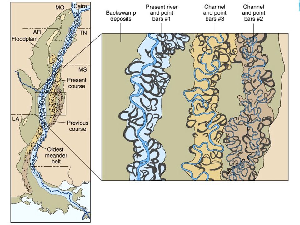
Meandering Streams All rivers flow in a sinuous pattern
Turbulent flow & velocity changes eroded one bank, deposit on the other Erosion changes course of river Deposition of point bars “fills in” old channel Oxbow lakes form in abandoned channel

41
Floodplains & meander evolution

43
Floodplain Features Embankments at river’s edge
Natural levees Embankments at river’s edge Flood waters flow over bank Rapid drop in velocity produces sand deposit Backswamps Low lying areas behind levees May be below river level Poorly drained

44
New Orleans, Natural Levees

45
Braided Streams Multiple channel system
Interlaced channels with islands High sediment load supplied with more sediment than it can transport. Common in arid & semi-arid regions Seasonal high flows Common in front of glaciers Large sediment load, fluctuating water flow

46
Alluvial Valleys Streams fill part of their valleys with sediment
Changes in hydrologic conditions initiate deposition Subsequently cut through deposits Create terraces

47
Alluvial Valleys: Stream Terraces

48
River Systems Stream valleys are the most common landforms on the continents. A river system consists of a main channel and all of the tributaries that flow into it, including: (a) a collecting system, (b) a transporting system, and (c) a dispersing system. The most important variables in stream flow are (a) discharge, (b) gradient, (c) velocity, (d) sediment load, and (e) base level. The variables in a stream constantly adjust toward a state of equilibrium. Rivers erode by (a) removal of regolith, (b) downcutting of the stream channel by abrasion, and (c) headward erosion. As a river develops a low gradient, it deposits part of its load on point bars, on natural levees, and across the surface of its floodplain. Most of a river’s sediment is deposited where the river empties into a lake or ocean. This commonly builds a delta at the river’s mouth. In arid regions, many streams deposit their loads as alluvial fans at the base of steep slopes. The origin and evolution of major rivers are controlled by the tectonic and hydrologic systems.
 a collecting system, (b) a transporting system, and (c) a dispersing system. The most important variables in stream flow are (a) discharge, (b) gradient, (c) velocity, (d) sediment load, and (e) base level. The variables in a stream constantly adjust toward a state of equilibrium. Rivers erode by (a) removal of regolith, (b) downcutting of the stream channel by abrasion, and (c) headward erosion. As a river develops a low gradient, it deposits part of its load on point bars, on natural levees, and across the surface of its floodplain. Most of a river’s sediment is deposited where the river empties into a lake or ocean. This commonly builds a delta at the river’s mouth. In arid regions, many streams deposit their loads as alluvial fans at the base of steep slopes. The origin and evolution of major rivers are controlled by the tectonic and hydrologic systems.")
51
Deltas Formed by sudden drop in velocity Stream enters ocean or lake
Stream drops sediment load Growth may be influenced by ocean waves

53
Delta Growth Distributaries Splays Avulsion
Levee and in-stream deposit formation Channel splits into two smaller channels Splays Crevasse allows water to leave main channel Water spreads out forming a splay deposit Avulsion Shift in main course

54
Formation of Distributaries

55
Avulsion

56
Nile River Delta Mississippi Delta Modified by waves and tides

57
Alluvial Fans Accumulation of sediment in a dry basin
Deposition due to rapid velocity drop Usually arid climate High sediment load - braided streams Form fan-shaped deposit

58
Alluvial fans in Death Valley

61
Floods Most common & lethal natural disaster
Most rivers experience seasonal flooding Flash floods are local, sudden events Caused by brief heavy rainfall Common in arid regions with high runoff

62
Rivers, Climates & Plate Tectonics
Rivers are influenced by precipitation The largest rivers are in the tropics Rivers are influenced by relief Tectonics may change principle slopes over time Continental collisions create uplifted mountains and depressed basins Rifting creates valleys Bedrock structures influence drainage patterns

63
River Systems Stream valleys are the most common landforms on the continents. A river system consists of a main channel and all of the tributaries that flow into it, including: (a) a collecting system, (b) a transporting system, and (c) a dispersing system. The most important variables in stream flow are (a) discharge, (b) gradient, (c) velocity, (d) sediment load, and (e) base level. The variables in a stream constantly adjust toward a state of equilibrium. Rivers erode by (a) removal of regolith, (b) downcutting of the stream channel by abrasion, and (c) headward erosion. As a river develops a low gradient, it deposits part of its load on point bars, on natural levees, and across the surface of its floodplain. Most of a river’s sediment is deposited where the river empties into a lake or ocean. This commonly builds a delta at the river’s mouth. In arid regions, many streams deposit their loads as alluvial fans at the base of steep slopes. The origin and evolution of major rivers are controlled by the tectonic and hydrologic systems.
 a collecting system, (b) a transporting system, and (c) a dispersing system. The most important variables in stream flow are (a) discharge, (b) gradient, (c) velocity, (d) sediment load, and (e) base level. The variables in a stream constantly adjust toward a state of equilibrium. Rivers erode by (a) removal of regolith, (b) downcutting of the stream channel by abrasion, and (c) headward erosion. As a river develops a low gradient, it deposits part of its load on point bars, on natural levees, and across the surface of its floodplain. Most of a river’s sediment is deposited where the river empties into a lake or ocean. This commonly builds a delta at the river’s mouth. In arid regions, many streams deposit their loads as alluvial fans at the base of steep slopes. The origin and evolution of major rivers are controlled by the tectonic and hydrologic systems.")
Similar presentations


 Flow to and/or gather in basin Evapotranspiration into air Condensation.>")


 B.Stream Velocity (controls and results) C.Drainage Patterns and Landscape Features (results.>")
 and rivers that flow down hill therefore changing.>")