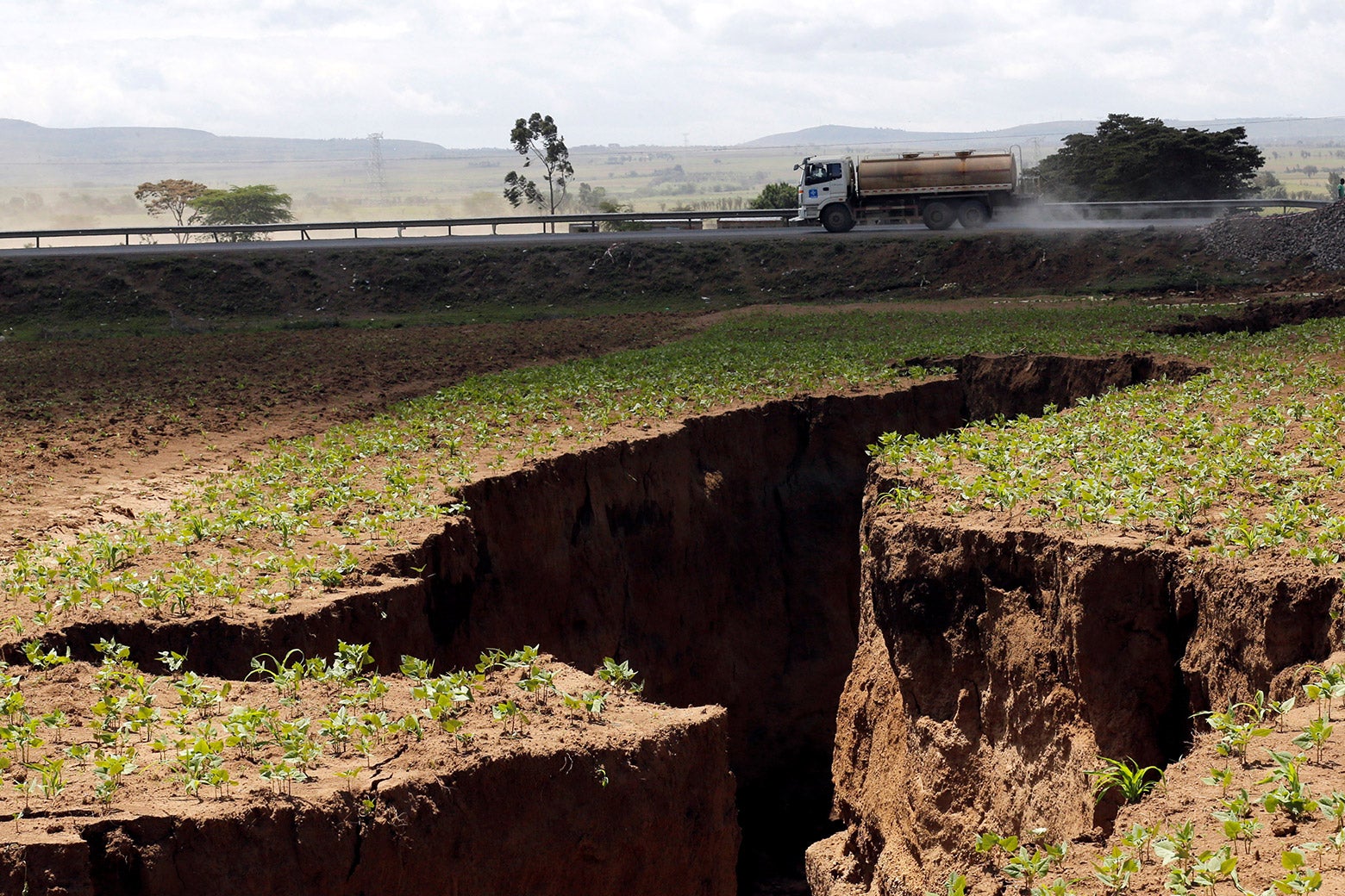
A miles-long fissure has opened in Kenya’s Rift Valley. The split, which first appeared in late March following weeks of heavy rain and tremors and has continued to expand since, called attention to a longer-term, larger-scale geological phenomenon that’s imperceptible until it isn’t: Africa is splitting in two.
Scientists haven’t yet reached a consensus on the exact mechanics of continental break-ups, but the fact that it’s happening here isn’t new or unexpected. Tectonic plates typically “glide” very, very slowly over the asthenosphere, the upper layer of the Earth’s mantle, most likely due to convection currents and forces acting at plate boundaries. But under certain conditions, those same forces can lead to a rupture, and ultimately to entirely new breaks in the plates.
The site of last week’s fissure is a prime example. The East African Rift was made possible in part by a superplume, a rising column of magma from within the Earth that’s weakened the lithosphere (the final layer of Earth’s crust, above the asthenosphere). The high heat from the plume forced the lithospheric mantle into a dome shape, and the stress from that process led to the breaks in the plate above.
As a result, the African plate is fragmenting into two, with the constituent Somali and Nubian plates moving away from each other at the normally negligible rate of 1.9-6.9 millimeters per year. The first of the fractures that make up the rift arose in the Afar region of Ethiopia around 30 million years ago. That’s where the separation is now happening the fastest—it’s there that we’ve seen early signs of what one researcher described as “the birth of a new ocean.” The break has been inching down toward Zimbabwe ever since, and eventually, when the lithosphere thins enough, the water will rush in, leaving parts of Ethiopia and Somalia as a new island.
There’s no imminent danger of a decisive split—the two main chunks of the continent will take tens of millions of years more to separate fully—but that’s not to say we can sit back and ignore it in the meantime. The smaller-scale, faster-paced events that add up to a geological phenomenon are just as momentous for the people living through them, and life along major fault lines comes with a host of hazards, as any Bay Area native can tell you. When the crack emerged in southwestern Kenya earlier this week, a section of the Narok-Nairobi highway collapsed, and some were forced to flee their homes. One house became so unstable it was ultimately demolished. With more downpours on the way over the next few months, residents will have to remain on the lookout for fresh cracks and sinking terrain.
While the rupture was by no means instantaneous, it did happen pretty quickly in geological terms—i.e., over a span of days rather than millennia. The incident highlights the need for contingencies along this rift and others like it. According to a 2018 paper published in Nature, the East African Rift System “remains one of the least monitored tectonic plate boundaries, which makes it challenging to constrain present-day seismic hazards.” To prevent or at least minimize such fallout in the future, information is key: If officials know about risks that come with the territory, which they didn’t in this case, they can plan its infrastructure accordingly, saving lives and livelihoods in the process. Comprehensive geological surveys—and consultation of the resulting data when deciding what to build and where to build it—could make all the difference.