
When I leave my warm sleeping bag and look at the thermometer it tells me that the inside of the van is -4°c. I knew it was getting cold in the middle of the night as my ears started to ache and I had to put my sleeping bag hood over my head. This is something I’ve only ever done a few times before, when sleeping in a tent at 15,000ft, you can read about those occasions here and here if you want to. When I check the outside temperature it’s -10°c so I know it’s going to be a cold walk up my designated hills of the day, Sour Howes and Sallows.

This is my second day in Troutbeck and today’s walk goes off in the opposite direction to yesterdays Wansfell hike. Crossing Church bridge over the charming little river I see a dipper darting back and forth on the rocks looking for breakfast. I have enjoyed the sound of Trout Beck, which, along with the hourly chimes of the church have lulled me off to the land of nod for the last two nights.

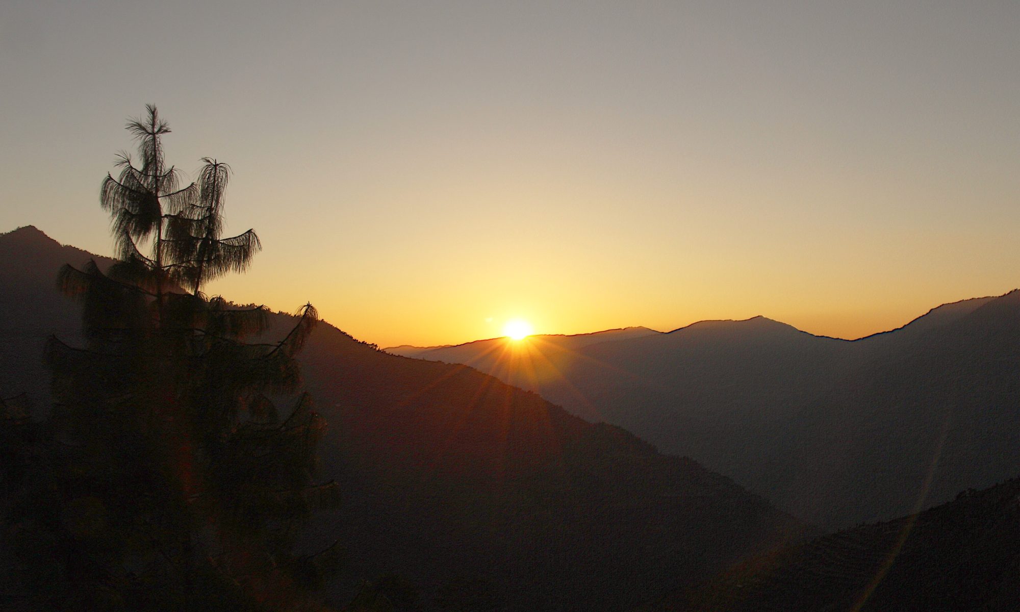
Just up the road, the footpath, actually a byway is signposted and heads upwards on a walled track through woodland and past Howe Farm. In the distance I hear a woodpecker, it’s short bursts of drilling into bark carrying on the still morning air. It’s another bright and sunny morning in Lakeland but it is bitterly cold. My breath condenses into a cloud as I exhale into the freezing air and reminds me how as children we used to pretend we were smoking on the winter walk to school. Those innocent days when smoking was cool and the fact that it would prematurely kill you was conveniently suppressed in the interest of profit.

Once past the buildings the gradient eases slightly and easy progress is made up the track. This ancient byway, the Garburn Road, is the old cart track between Troutbeck and Kentmere and the bright green moss and lichens on the dry-stone boundary walls bare testimony to its age and history. If the moss could talk the stories it would tell.

Looking over my shoulder there is a very picturesque view. The morning mist hangs still in the valley and in the distance the snow spattered Coniston Fells stand out sharp against the pale blue cloudless sky. In between, a white cottage wall is lit up by the sun and on the hillside, equally white sheep are dotted on frosty green fields. Lakeland captured in a picture.

I leave the Garburn Road at a stile, cross a field, over another stile then onto the open fellside which leads up to Sour Howes. It’s a decent, steady climb up through rock outcrops and heather until the summit of Sour Howes is reached. I say summit, but the high ground around the summit rather resembles telly tubby land with lots of round scattered lumps all vying to be the highest spot. I settle on the mound that looks the most pointy and from the boot prints seems to be the peoples choice.

Sour Howes is the fiftieth Wainwright on my journey through the Wainwrights. I don’t usually plan more than two days walking in advance and even then I sometimes change the days around depending on the weather so the privilege of being number Fifty only fell to Sour Howes yesterday. I do know what number 214 is going to be but I will keep that to myself for now.

There are good views down to Windermere, although not as good as yesterday, and around the head of the valley named Wardless on the OS map I can see my second hill, Sallows, thirty metres above me on the other side. The grass path curves around the head of the valley and before long I am standing on top of Sallows. The best view from here is across the Garburn Pass to the western flank of the Kentmere horseshoe and up the Troutbeck valley.

I settle down for a bite to eat and some hot chocolate and am joined by another solitary walker. We chat and he expresses the same thoughts about the top of Sour Howes not being the easiest to define. It turns out he had a heart attack some months ago and is slowly getting back to full health. I admire his confidence in walking alone so soon after a major health scare and wonder if I would be the same. God willing I won’t have to find out.

From the summit it’s a short walk down on hard frozen ground to the top of the Garburn Pass at a little plantation called Garburn Nook. Here the Garburn road is rejoined which I will follow all the way back to the start. The scenery is good and the day has stayed clear and sunny. Although it is well below freezing I am wrapped up in my thickest New Zealand Merino and down jacket so I am not feeling the cold.

As mentioned the Garburn road is a byway. Prior to 2011 it was unrestricted which meant that motorised vehicles could use it until they were banned. Now only walkers and mountain bikers are allowed. A debate could be had over whether boots or tyres cause the most damage on these ancient lanes but in parts, the track is in a pretty sorry condition. Some sections look like someone’s demolished a house and dumped the rubble on the path to walk over.


The scenery more than makes up for the inconvenience of a rough path though. The low winter afternoon sun casts a soft, warm colour onto the frozen landscape which is attractive to the eye and calming to the mind. It strobes through the pines, their long shadows stretching out along the path, and dazzles off the frozen water that has turned parts of the track into an impromptu ice rink.

And it is in this mindful, satisfied frame of mind that I finish the walk. I call in at Jesus Church but it is locked so head up the hill to the Old Post Office Tea Room where I enjoy coffee and cake, lemon I think. Surely all walks should end this way.

Route Map, Walk Stats, Geolocated Picture Gallery and 3D Flyover Video Below.
Click ‘Learn more’ on the map. Note: you won’t see the map if reading in WordPress reader but click on the little world at the top of the page to view it on the browser.

Looks amazing! And a well deserved cake ❤️
Thank you, I always enjoy a cake, deserved or not!
It is also good to end a walk with a cold beer, but on this occasion, I think you are cold enough! Thanks for the wintery stroll, Mel
Thanks Mel, yes a cold beer on a hot summers evening, sitting in a beer garden is a good end to a walk
Your photos are great. Lakeland in a picture is exceptional.
Thank you Ruth, yes I do like that one, I think it will go on the ‘must print off and frame one day’ list. 😀
Absolutely best way to end a walk. That mist on the valley shot is a gem. Such a crystal clear lovely day but I could feel my ears aching with the cold 🥶 😘
Thank you Jo, yes I do like that picture, taken on my ‘proper’ camera. it’s a lesson learned because I am lazy and take too many pics on my phone.
I have a new phone and am just getting to grips with the camera but my ‘proper’ camera is a tiny Isus and very easy. I do admire you for tackling these walks on your own. It’s something I would never dare to do 😍
Phone cameras are excellent these days. My DSLR weighs 1kg so I rarely take it up hills. I have a LUMIX TZ200 which is far better than my phone but it still doesn’t stop me taking too many lazy phone pics!
In the moment! 😁💖
Looks beautiful, though very cold! Coffee and cake deserved.
Thank you Shazza, yes it was cold and I did enjoy the cake!
Fantastic weather for that walk, they those two are always derided as boring but I quite liked the pair of them especially as our weather was similar to your
Thanks Steve, yes I enjoyed them and the weather was fantastic
An interesting post with some very nice images.
Thank you Peter