- Purpose and Intent. The intent of the Planned Community Mixed-Use (PCMU) Code is to promote and foster a traditional mixed-use neighborhood and village center including opportunities to live, work, shop and recreate while preserving the rural character of the Heber Valley. With proper form, a greater integration of building uses is natural, comfortable, and ecologically sustainable. This Code created this form-Multiple residential uses, minor commercial areas, civic spaces, and a network of streets and trails. The regulations of the PCMU Code contained herein are designed to: 1)Encourage the City to do detailed planning based on design and form rather than Euclidian Zoning; 2) Cultivate holistic neighborhoods that include a framework of pedestrian and bicycle systems, which provide alternatives to the automobile, allowing independence for those who do not drive or choose to drive less; 3) Promote creative and indigenous landscape and architecture that blends in with the natural surroundings and follows project specified design guidelines; 4) Stimulate the local economy and increase the tax base of the City; 5) Promote the preservation of agricultural lands, open space, scenic vistas, natural features and respect historical precedents by increasing density within the City; 6) Establish guiding principles through language and images for all new community development within the PCMU Zone and to ensure that the economic, environmental, and social justice needs of a community are met; 7) Regulate and control development in Heber City to produce safe, attractive, and enjoyable public spaces complemented with a healthy mix of uses; and 8) Promote affordable housing by offering multiple housing types within each neighborhood.
- Applicability. Provisions of this Code are activated by “shall” when required; “should” when recommended; and “may” when optional. The provisions of this Code, when in conflict with other City Ordinances, shall take precedence over those of other Codes, Ordinances, Regulations, and Standards except adopted IBC (International Building Code) Standards. The Code and Ordinances of the City continue to be applicable to issues not covered by this PCMU Ordinance, except where these would contradict the Purpose and Intent Section, in which case the conflict shall be resolved in favor of this Code. Terms used throughout this Code shall be accorded their commonly accepted meanings or as defined in the Definitions of Terms Section. In the event of conflicts between these definitions and those of other City Ordinances, those of this Code shall take precedence.
- Structure of the Code. The Planned Community Mixed-Use Code uses simple language and clear graphic prescriptions and parameters for building height, building site, and building elements to address the basic necessities for forming good public spaces.
- Authority. The Planned Community Mixed-Use Code is a legal document that regulates land development by setting careful and coherent controls on building form while employing more flexible parameters relative to building use and density. This Code was adopted to promote the health, safety and general welfare of residents of Heber City, conserve agricultural land, conserve energy and natural resources, reduce vehicular traffic, encourage walkability, support downtown Heber City, and reduce suburban sprawl development.
- Instructions. Property identified as Planned Community Mixed Use (PCMU) in the General Plan shall be either: a) annexed into the City as Planned Community Mixed-Use (PCMU) Zoned land, or b) rezoned through the Heber City Rezone process as Planned Community Mixes-Use (PCMU) Zoned land. PCMU plans may be prepared by an owner, design consultant, developer, or by Heber City, but shall adhere to the following guidelines:
- Each PCMU Master Plan shall respond to the existing conditions of the site, adjacent developments, connecting Thoroughfares, and natural features.
- Each PCMU Master Plan shall be structured as a Walkable Neighborhood of ¼ mile radius as outlined in this PCMU Code.
- Each PCMU Master Plan shall allocate the Transect Districts as outlined in the Transect Districts Section.
- Each PCMU Master Plan shall lay out the Thoroughfare network according to Section E Streetscape Requirements and Tables 14a-d.
- Each PCMU Master Plan shall allocate Civic Space according to Section F Civic Functions and Open Space.
- Each PCMU Master Plan shall include a set of building standards prepared in accordance with the requirements in the Building Scale Plans Section.
- Each PCMU Master Plan shall have approved by the Heber City Planning Commission a set of written design guidelines with graphic images, to establish a coherent exterior character of lasting quality of development.
- Each PCMU Master Plan shall consist of a minimum of 60 contiguous acres. Sites contiguous to a PCMU Master Plan may incorporate at any time upon approval of Heber City, annexation and with appropriate illustrations and written descriptions of compliance to the PCMU Master Plan and the projects Design Guidelines.
- Each PCMU Master Plan shall include a street tree master plan that is in accordance with Tables 5, 6 and 13.
- Each PCMU Master Plan shall include a buffer from all State Highways. All highway buffers shall be 50’ minimum or as approved in the Master Plan process.
TABLE 1: District Descriptions.

- Transect Districts. The Planned Community Mixed-Use (PCMU) Code utilizes the Transect Districts. These Districts are a system of ordering human habitats in a range from the most natural to the most urban. It is based upon six districts which describe the physical character of place at any scale, according to the density and intensity of land use and urbanism. Heber City PCMU’s zone will utilize two (2) of these districts: Transect Districts Three, which is Neighborhood General and Transect District Four, Village Center. Although this Code is specifically adopted for using Districts Neighborhood General (NG) and Village Center (VC), other districts may be added if the Heber City Council decides to expand the Code. Transect Districts shall be constituted of the elements described in Table 1 in the Development Requirements, Standards, and Tables Section. Each proposed PCMU plan shall allocate Transect Districts with the percentage use ranges outlined below. The districts available for inclusion in a PCMU Zone are:
- Neighborhood General (NG) – the most natural, least dense, most Residential of the urbanized areas. At least 40% of each PCMU plan must utilize this District.
- Village Center (VC) – the most varied Residential area (mixed-use allowed). At least 20% of each PCMU plan must utilize this District.
- Neighborhood General (NG) – the most natural, least dense, most Residential of the urbanized areas. At least 40% of each PCMU plan must utilize this District.
- Density Calculations & Housing Mix
- The Developable Areas of the site shall be considered the Net Site Area. The Net Site Area shall be allocated to the various Districts according to the parameters specified in Table 2.
- The Overall Density shall be calculated in terms of housing units as specified for the area of each District by Table 2.
- For purposes of Density, calculations shall be based on the gross application boundary.
- A minimum residential housing mix shall be required within each District as follows:
- NG ‘Neighborhood General’ – at least two residential types as delineated in Table 8a, with each type at least 30% of the total units within NG Districts.
- VC ‘Village Center’ – at least three residential types as delineated in Table 8a, with each type at least 20% of the total units within VC Districts.
- Residential Mixed-Use shall constitute a minimum of 10% of the housing in VC except when VC’s are 25 acres or less.
- NG ‘Neighborhood General’ – at least two residential types as delineated in Table 8a, with each type at least 30% of the total units within NG Districts.
- Project applicants may jointly apply with adjacent project applicants to satisfy the minimum residential density and housing mix requirements.
- The Developable Areas of the site shall be considered the Net Site Area. The Net Site Area shall be allocated to the various Districts according to the parameters specified in Table 2.
- Environmental Requirements. Districts manifest a range of responses to natural and urban conditions. PCMU Master Plans shall include a street tree master plan dictating the chosen species and spacing per street.
- General
- To the extent not inconsistent with Heber City Code, development shall not occur on slopes above 30%, in areas with high landslide potential or in aquifer regeneration areas.
- To the extend not inconsistent with Heber City Code, all Army Corps of Engineers designated wetlands shall not be developed and shall include a 30 foot buffer around the entire perimeter except by Conditional Use.
- Sensitive lands like those with high water tables or important wildlife habitats shall be preserved except where authorized by the City Council.
- All land within Master Planned boundaries which are preserved for any of the above reasons, may be calculated as Civic Open Space.
- To the extent not inconsistent with Heber City Code, development shall not occur on slopes above 30%, in areas with high landslide potential or in aquifer regeneration areas.
- Specific to Neighborhood General District (NG)
- Within NG Districts, the continuity of the urbanized areas shall be subject to the precedence of the natural environmental condition. The alteration of such conditions shall be limited according to local, state, and federal law.
- The Public Frontage (Tables 5 & 2D) shall include trees of a consistent species by street, planted in an organized boulevard fashion, as well as low maintenance understory. The introduced landscape shall consist primarily of native and/or drought tolerant species requiring minimal irrigation, fertilization and maintenance. (Tables 4 and 13). Lawn should only be used when necessary for public recreation parks and residential lots but should be kept to a minimum when and where possible. Street trees shall be a species that at mature height are over 45 feet.
- Impermeable surface shall be confined to the lot coverage as specified in Table 2F except that commercial lots may exceed that standard by up to 15%.
- To the extent not inconsistent with applicable state or federal law, storm water management on Thoroughfares should be where possible, primarily through detention and percolation, channeled by curbside swales.
- Within NG Districts, the continuity of the urbanized areas shall be subject to the precedence of the natural environmental condition. The alteration of such conditions shall be limited according to local, state, and federal law.
- Specific to Village Center Districts (VC)
- To the extent not inconsistent with applicable state or federal law, within VC Districts, the continuity of the urbanized areas should take precedence over the natural environmental conditions. The alteration of such conditions, where necessary, may be mitigated off-site, and the determination for modification and mitigation shall be made by Conditional Use.
- The Public Frontage (Tables 5 & 2D) shall include trees planted in a regularly-spaced pattern of a single species (per street) with shade canopies and mature height of over 40 feet.
- The introduced landscape shall consist primarily of durable species tolerant of soil compaction (Tables 4 & 13).
- Impermeable surface shall be confined to the lot coverage as specified in Table 2F except that commercial lots may exceed that standard by up to 15%.
- To the extent not inconsistent with applicable state or federal law, storm water management on Thoroughfares and lots shall be primarily through underground storm drainage channeled by raised curbs, and there shall be no retention or detention required on the individual lots. All detention areas shall be planned on a Master Plan basis. Curbside swales shall be permitted by Warrant and as required in PCMU Design Guidelines.
- To the extent not inconsistent with applicable state or federal law, within VC Districts, the continuity of the urbanized areas should take precedence over the natural environmental conditions. The alteration of such conditions, where necessary, may be mitigated off-site, and the determination for modification and mitigation shall be made by Conditional Use.
- General
- Streetscape Requirements
- General
- Thoroughfares are intended for use by vehicular, bicycle and pedestrian traffic and to provide access to lots and open spaces.
- The Thoroughfares consist of vehicular lanes and Public Frontage (Table 3). The lanes provide the traffic and parking capacity. They consist of vehicular lanes in a variety of widths for parked and for moving vehicles. The frontages contribute to the character of the Transect District. They include the types of sidewalk, curbing, planter, and street tree.
- Thoroughfares should be designed to context with the urban form and desired design speed of the Districts through which they pass. Thoroughfares that pass from one District to another shall adjust their Public Frontages accordingly or, alternatively, the Transect District may follow the alignment of the thoroughfare to the depth of one lot, retaining a single Public Frontage throughout its trajectory.
- Within urban Transect Districts NG and VC pedestrian comfort shall be a primary consideration of the Thoroughfare. Design conflict between vehicular and pedestrian movement shall be decided in favor of the pedestrian.
- Thoroughfares are intended for use by vehicular, bicycle and pedestrian traffic and to provide access to lots and open spaces.
- Thoroughfares
- The standards for vehicular lanes shall be a shown in Tables 14a-e.
- The Thoroughfare network shall be designed to define blocks not exceeding the size prescribed in Table 2C. The size shall be measured as the sum of lot Frontage Lines.
- All Thoroughfare shall terminate at other Thoroughfares, forming a network. Internal Thoroughfares shall connect wherever possible to those on adjacent sites. Cul-de-sacs shall be permitted only by Warrant when natural site conditions justify.
- Lots shall front on a vehicular Thoroughfare, except that 20% of the lots within each District may front a pedestrian passage.
- A bicycle network consisting of Bicycle Trails, Routes and Lanes shall be provided throughout as allocated in Table 2D. The community bicycle network should be connected to existing or proposed Sector networks wherever possible.
- To accommodate anticipated traffic volumes along Heber City Master Planned Arterial and Collector Streets that traverse through a PCMU development, the adopted PCMU street standard may be modified by Warrant, acceptable to the City, so long as traffic calming measures are implemented in a manner consistent with the intent of the PCMU.
- The standards for vehicular lanes shall be a shown in Tables 14a-e.
- Public Frontages
- Public Frontages shall be designed as shown in Table 5 and allocated within Districts as specified in Table 2D.
- Within the public frontages, the prescribed type of street trees and street lights shall be as shown in Tables 12 and 13. The spacing may be adjusted by Warrant to accommodate specific site conditions.
- Public Frontages shall be designed as shown in Table 5 and allocated within Districts as specified in Table 2D.
- General
- Civic Functions and Open Space
- General
- Certain places for public use shall be required for each community and designated on the PCMU Plans as Civic Space (CS) and Civic Building (CB).
- Civic Spaces are public sites permanently dedicated as open space. Civic Spaces are limited to those described in Table 7 and by any trail network within the development boundaries.
- Civic Buildings are sites generally dedicated to culture, education, government, religious and transit, or for a use approved by the Heber City Council.
- Certain places for public use shall be required for each community and designated on the PCMU Plans as Civic Space (CS) and Civic Building (CB).
- Civic Space (CS) Specific to NG-VC
- Each Walkable Neighborhood shall assign at least 15% of its area to Civic Space.
- Civic Spaces shall be designed as generally described in Table 7 and allocated to districts as described in Table 2E.
- Each Walkable Neighborhood shall contain at least one main Civic Space. The main Civic Space shall be within 400 feet of the Village Center core of each Walkable Neighborhood, unless pre-existing conditions warrant a greater distance.
- Within 1000 feet of every lot in Residential use, a Civic Space designed and equipped as a playground shall be provided.
- As an incentive, Walkable Neighborhoods with Civic Space in excess of 15% may receive the additional density of one (1) unit per gross acre on the overall density for every 4% increase in Civic Space. Density bonus shall start at 16% for one (1) bonus unit and cap at 32% for five (5).
- Improvements must be made in the form of landscaping and/or trails to park sites in order to qualify them for inclusion on the density bonus calculations for Civic Space.
- There shall be a minimum of one (1) Civic Space per 60 acres of the gross site.
- Each Civic Space shall have a minimum of 30% of its perimeter enfronting a Thoroughfare.
- Each Walkable Neighborhood shall assign at least 15% of its area to Civic Space.
- Civic Buildings (CB) Specific to NG-VC Districts
- A minimum of one Civic Building is encouraged within each Walkable Neighborhood which may include: a childcare facility, senior care facility, library or other related community center, cultural center, religious building, post office and/or protective buildings like police stations. The Developer or a Homeowners’ Association or other Community Council may also organize, fund and construct an appropriate building as the need arises.
- Civic Building lots within each PCMU Zone shall not be included as part of the required Civic Space calculations but may be used in Civic Space density bonus calculations.
- Civic Building sites shall not occupy more than 10% of the area of each Walkable Neighborhood except by Warrant.
- Civic Building sites should be located within or adjacent to Civic Spaces, or at the axial termination of significant Thoroughfares.
- Civic Buildings shall not be subject to the standards of Section 18.62.030 (Building Scale plans). The particulars of their design shall be determined by Conditional Use Permits.
- A minimum of one Civic Building is encouraged within each Walkable Neighborhood which may include: a childcare facility, senior care facility, library or other related community center, cultural center, religious building, post office and/or protective buildings like police stations. The Developer or a Homeowners’ Association or other Community Council may also organize, fund and construct an appropriate building as the need arises.
- General
- General Regulations. The following are requirements related to the definition of terms. For an actual definition of the following terms, refer to Section 18.62.070, Definitions of Terms.
- Accessory Unit: shall not count toward maximum density calculations and shall not count as one of the required residential types of either Districts.
- Cottage: shall not be on lots larger than 4000 sq/ft. Cottages on Green Courts should not be on lots larger than 2500 sq/ft.
- 2nd Layer: the façade of a building shall not include porches or stoops unless they constitute more than 75% of the façade.
- Basement: shall not be counted as a story in building height calculations unless the basement ceiling exceeds four (4) feet above the ground level on the street facing side of the building. On corner lots this regulation is only require for one street facing side of the building.
- Driveway: Driveways in the First Layer may be used for parking if it is not more than 18 feet wide, thereby becoming subject to the constrains of a parking lot.
- Streetscreen: shall be between 3 and 6 feet in height and constructed of a material matching the adjacent building façade.
- Accessory Unit: shall not count toward maximum density calculations and shall not count as one of the required residential types of either Districts.
- Additional Requirements. A Planned Community Mixed-Use plan shall designate the following special requirements by reference in the Design Guidelines. They shall hence forth be enforced by a DRC (Design Review Committee) or the City:
- A differentiation of the Thoroughfares as a Primary-Grid (P-Grid) and a Secondary-Grid (S-Grid). Buildings along the P-Grid shall be held to the highest standard of this Code in support of pedestrian activity. Buildings along the S-Grid may be more readily considered for Warrants and Conditional Uses allowing automobile-oriented standards. The Frontages assigned to the S-Grid shall not exceed 30% of the total length within a Walkable Neighborhood.
- A mandatory Retail frontage requiring that a building provide a shop front at sidewalk level along the entire length of the Frontage. The Shop fornt shall be no less than 70% glazed in clear glass and provided with an awning overlapping the sidewalk as generally illustrated in Table 6. The first floor shall be confined to Retail use through the depth of the Second Layer. (See Table 3D)
- A Coordinated Streetscape Frontage, requiring that the Public and Private Frontages be coordinated as a single, coherent landscape and paving design.
- A Terminated Vista location, requiring that the buildings in these locations be provided with architectural articulation of a type and character that responds to the location.
- A Cross Block Passage, requiring a minimum 6 foot-wide pedestrian access be reserved between structures and/or every 350 feet as a minimum.
- A Buildings of Value requirement stating that historically significant buildings and structures be preserved except by Warrant.
- A requirement for the preservation of View Corridors.
- A requirement of building and landscaping materials which contribute to the historical feel and nature of Heber City.
- A requirement of one sitting space for every 60 square feet of plaza space.
- A differentiation of the Thoroughfares as a Primary-Grid (P-Grid) and a Secondary-Grid (S-Grid). Buildings along the P-Grid shall be held to the highest standard of this Code in support of pedestrian activity. Buildings along the S-Grid may be more readily considered for Warrants and Conditional Uses allowing automobile-oriented standards. The Frontages assigned to the S-Grid shall not exceed 30% of the total length within a Walkable Neighborhood.
TABLE 2: PLANNED COMMUNITY MIXED USE CODE SUMMARY – This is a summary of all the statistics and other metrics that appear throughout this Code, including those that appear on other tables. This table may be used as a checklist, both by developers for design and by regulators for permit processing.
- Specific to Neighborhood General Transect Districts (NG)
- Building Disposition (NG)
- Newly platted lots shall be dimensioned according to Table NG.
- Buildings shall be placed in relation to the boundaries of their lots according to Table NG.
- One Principal Building at the Frontage, and one Out Building to the rear of the Principal Building, may be built on each lot as shown in Table 3C.
- Lot coverage by building shall not exceed that shown in Table NG.
- Facades shall be built parallel to a rectilinear Principal Frontage Line or parallel to the tangent of a curved Principal Frontage Line.
- Setbacks for Principal Buildings shall be as shown in Table 2G.
- Rear Setbacks for Out Buildings shall be a minimum of 3 feet measured from the edge of the Alley or Rear Lane easement or property line in the absence of a Rear Alley or Lane. Corner lots on Alleys or Lanes are not subject to Rear Setbacks for Corner Lot Conditions.
- A minimum Residential housing mix of two Types (none less that 30% and one type being detached housing) shall be required in the Neighborhood General District, selected from Table 8.
- All lot widths shall conform to those standards in Table 2 except that 20% of lot widths may exceed the max frontage width by up to 20 feet.
- Setbacks shall be measured from the front of buildings or from porches when porches make up over 60% of the building frontage.
- Building Configuration (NG)
- Private Frontage types shall conform to and be allocated in accordance with Table 6 and Table NG.
- Building Heights shall conform to and be as shown in Table NG. Basements shall not be included in building height calculations to the extents described in the General Regulations of this document.
- Parking Standards (NG)
- Vehicular parking shall be required and adjusted for mixed-use as shown in Table 11.
- On-street parking available along the Frontages Lines that correspond to each lot shall be counted toward the parking requirement of the building on the lot but not for residential.
- Residential parking shall be accessed by the Alley or Rear Lane except where slope or other related conditions permit otherwise.
- Parking lots shall be masked from the Frontage by a Liner Building or Streetscreen.
- Open parking areas shall be located at the Second and Third Lot Layers (rear of building) as shown in Table 3D, except that Driveway aprons and drop-offs may be located at the First Layer (front of building). Garages shall be located at the Third Layer.
- The required parking for commercial may be provided within 600 feet of the site it serves, subject to approval by Conditional Use.
- Architectural Standards (NG)
- Streetscreens should be between 3.5 and 8 feet in height and constructed of a material matching the adjacent building Façade. The Streetscreen may be replaced by a hedge or fence by Warrant. Streetscreens shall have openings no larger than necessary to allow automobile and pedestrian access.
- b. Openings above the first Story shall not be less than 25% of the total building wall area, with each Façade being calculated independently.
- All primary commercial entrances shall Enfront a ROW except by Warrant.
- All single family housing units shall have covered porches that are at least six (6) feet deep.
- Environmental Standards (NG)
- Transect Districts manifest a range of responses to natural and urban conditions. In case of conflict, to the extent not inconsistent with applicable state or federal law, the natural infrastructure shall have priority in District NG.
- The landscape installed shall consist primarily of native and/or drought tolerant species requiring minimal irrigation, fertilization and maintenance.
- Impermeable surface shall be confined to the lot coverage as specified in Table 2F except that commercial lots may exceed that standard by up to 15%.
- Transect Districts manifest a range of responses to natural and urban conditions. In case of conflict, to the extent not inconsistent with applicable state or federal law, the natural infrastructure shall have priority in District NG.
- Landscape Standards (NG)
- Street trees shall be of a consistent species by street, planted in an organized boulevard fashion, with an understory stall below for maintenance.
- Lawn shall be permitted on specifications of Design Guidelines.
- Block perimeters shall not exceed 2000 feet except when pedestrian passages bisect the block in at least 350 foot intervals.
- Street trees shall be of a consistent species by street, planted in an organized boulevard fashion, with an understory stall below for maintenance.
- Signage Standards (NG)
- One blade sign is permitted for each commercial business, not including the address of the building except that corner commercial uses may have one sign per street facing façade. Each blade sign shall not exceed 8 square feet and may be attached either perpendicular or parallel to the building frontage. Projecting blade signs shall clear 8 feet measured from the ground to the bottom of the sign and shall not encroach the public sidewalk more than 3 feet, and must be setback from other commercial uses blade signs a distance of at least 10 feet.
- One monument sign is permitted for each commercial lot by Warrant. Monument signs shall not exceed 8 feet in height, 32 square feet in area, and shall be setback at least 3 feet from any street property line or driveway, and setback from any side property line at least 8 feet. Monument signs providing advertising for buildings which contain multiple businesses shall primarily identify the building by name and may provide, to a lesser extent, space for advertisement of each of the multiple businesses within the building. Blade signs, rather than monument signs, should serve as the primary advertising sign for commercial businesses.
- All signs shall be made of permanent, lasting material. Plywood and vinyl materials are prohibited.
- Signs within a window shall not exceed 25% of the area of the window, but in no case shall the total area of all window signs for each commercial business exceed 12-square feet.
- Off-premise signs, billboards, and all sign types not specifically mentioned and permitted by this Section are strictly prohibited.
- Home Occupation signs are prohibited in NG.
- One blade sign is permitted for each commercial business, not including the address of the building except that corner commercial uses may have one sign per street facing façade. Each blade sign shall not exceed 8 square feet and may be attached either perpendicular or parallel to the building frontage. Projecting blade signs shall clear 8 feet measured from the ground to the bottom of the sign and shall not encroach the public sidewalk more than 3 feet, and must be setback from other commercial uses blade signs a distance of at least 10 feet.
- Ambient Standards (NG)
- Streetlights shall be of a general type illustrated in Table 12.
- Outdoor storage shall be screened from view from any Frontage by a Streetscreen.

- Streetlights shall be of a general type illustrated in Table 12.
- Building Disposition (NG)
- Specific to Village Center Transect Districts (VC)
- Building Disposition (VC)
- Newly platted lots shall be dimensioned according to Table VC.
- Buildings shall be placed in relation to the boundaries of their lots according to Table VC.
- One Principal Building at the Frontage, and one Out Building to the rear of the principal Building, may be built on each lot as shown in Table 3C.
- Lot coverage by building shall not exceed that shown in Table VC.
- Facades shall be built parallel to a rectilinear Principal Frontage Line or parallel to the tangent of a curved Principal Frontage Line.
- Setbacks for Principal Buildings shall be a shown in Table 2G.
- Rear Setbacks for Out Buildings shall be a minimum of 3 feet measured from the edge of the Alley or Rear Lane easement or property line in the absence of a Rear Alley or Lane. Corner lots on Alleys or Lanes are not subject to Rear Setbacks for Corner Lot Conditions.
- Building Types shall be as shown in Table 10.
- A minimum Residential housing mix of three Types (none less than 20%) shall be required in the Village Center District, selected from Tables 8 and 9.
- Vertical residential mixed-use shall be a minimum of 10% of each VC except in Village Centers less than 25 acres.
- Commercial Building lots shall not exceed the requirements shown in Tables 2 and VC except by Warrant.
- Newly platted lots shall be dimensioned according to Table VC.
- Building Configuration (VC)
- Private Frontage types shall conform to and be allocated in accordance with Table 6 and Table VC.
- Awnings may encroach the public sidewalk without limit. Stoops may encroach 100% of the depth of a Setback. Open porches and awnings may encroach up to 50% of the depth of the Setback. Balconies and bay windows may encroach up to 25% of the depth of the Setback.
- Loading docks and service areas shall be permitted on Frontages only by Warrant.
- Building Heights shall conform to and be a shown in Table VC. Basements shall not be included in building height calculations to the extents described in the General Regulations of this document.
- Private Frontage types shall conform to and be allocated in accordance with Table 6 and Table VC.
- Building Function and Density (VC)
- Buildings in VC Districts shall conform to the Functions described in Tables 8 and 9. Functions that do not conform to the requirements of these tables shall require approval by Warrant.
- Buildings in VC Districts shall conform to the Functions described in Tables 8 and 9. Functions that do not conform to the requirements of these tables shall require approval by Warrant.
- Parking Standards (VC)
- Vehicular parking shall be required as shown in Table 11.
- On-street parking available along the Frontage Lines that correspond to each non-residential lot shall be counted toward the parking requirement of the non-residential uses on the lot.
- Residential parking shall be accessed by the Alley or Rear Lane except by Warrant.
- Parking lots shall be masked from the Frontage by a Liner Building or Streetscreen.
- All parking areas except for Driveways shall be located at the Third Layer as illustrated in Table 3D. Garages shall be at the Third Layer.
- The required parking for commercial may be provided within 600 feet of the site it serves, subject to approval by Conditional Use.
- Shared parking lots shall be permitted.
- Residential parking may be within shared lots but shall remain private and marked per its user
- A minimum of one bicycle stall, provided in a designated bicyclerack, shall be required for every eight (8) parking stalls and shall be provided within the Public or Private Frontage.
- Vehicular parking shall be required as shown in Table 11.
- Architectural Standards (VC)
- Streetscreens should be between 3.5 and 8 feet in height and constructed of a material matching the adjacent building Façade. The Streetscreen may be replaced by a hedge or fence by Warrant. Streetscreens shall have openings no larger than necessary to allow automobile and pedestrian access.
- Each PCMU District shall have a set of Design Guidelines which outline the specific architectural styles and materials permitted within the development.
- All primary entrances for housing shall Enfront a ROW except that 25% of lots within VC may Enfront a pedestrian passage or civic space.
- All single family housing units shall have covered porches that are at least six (6) feet deep.
- Streetscreens should be between 3.5 and 8 feet in height and constructed of a material matching the adjacent building Façade. The Streetscreen may be replaced by a hedge or fence by Warrant. Streetscreens shall have openings no larger than necessary to allow automobile and pedestrian access.
- Environmental Standards (VC)
- Transect Districts manifest a range of responses to natural and urban conditions. In case of conflict, to the extent not inconsistent with applicable state or federal law, the urban infrastructure shall have priority in Districts (NG-VC).
- The species of landscape installed shall consist primarily of native and/or drought tolerant species adaptable to soil compaction.
- Impermeable surface shall be confined to the lot coverage as specified in Table 2F except that commercial lots may exceed that standard by up to 15%.
- To the extent not inconsistent with applicable state or federal law, storm water management on Thoroughfares and lots shall be primarily through underground storm drainage channeled by raised curbs, and there shall be no retention or detention required on the individual lots. All detention areas shall be planned on a Master Plan basis. Curbside swales shall be permitted by Warrant and as required in PCMU Design Guidelines.
- Transect Districts manifest a range of responses to natural and urban conditions. In case of conflict, to the extent not inconsistent with applicable state or federal law, the urban infrastructure shall have priority in Districts (NG-VC).
- Landscape Standards (VC)
- Street trees shall be of a consistent species by street, planted in an organized boulevard fashion, with an understory stall below for maintenance.
- Lawns shall be permitted.
- Block perimeters shall not exceed 2000 feet except when pedestrian passages bisect the block in intervals of at least 300 feet.
- Street trees shall be of a consistent species by street, planted in an organized boulevard fashion, with an understory stall below for maintenance.
- Signage Standards (VC)
- One blade sign is permitted for each commercial business, not including the address of the building except that corner commercial uses may have one sign per street fronting façade. Each blade sign shall not exceed eight (8) square feet and may be attached either perpendicular or parallel to the building frontage. Projecting blade signs shall clear eight (8) feet measured from the ground to the bottom of the sign and shall not encroach the public sidewalk more than three (3) feet, and must be setback from other commercial uses blade signs a distance of at least ten (10) feet.
- One monument sign is permitted for each commercial lot by Warrant. Monument signs shall not exceed eight (8) feet in height, thirty-two (32) square feet in area, and shall be setback at least three (3) feet from any street property line or driveway, and setback from any side property line at least eight (8) feet. Monument signs providing advertising for buildings which contain multiple businesses shall primarily identify by name and may provide, to a lesser extent, space for advertisement of each of the multiple businesses within the building. Blade signs, should serve as the primary advertising sign for commercial businesses.
- All signs shall be made of permanent, lasting material. Plywood and vinyl materials are prohibited.
- Signs within a window shall not exceed 25% of the area of the window, but in no case shall the total area of all window signs for each commercial business exceed 12 square feet.
- Off-premise signs, billboards, and all sign types not specifically mentioned and permitted by this section are strictly prohibited.
- Within the VC, home occupation signs are permitted only as a projecting or parallel blade sign not exceeding two (2) square feet.
- One blade sign is permitted for each commercial business, not including the address of the building except that corner commercial uses may have one sign per street fronting façade. Each blade sign shall not exceed eight (8) square feet and may be attached either perpendicular or parallel to the building frontage. Projecting blade signs shall clear eight (8) feet measured from the ground to the bottom of the sign and shall not encroach the public sidewalk more than three (3) feet, and must be setback from other commercial uses blade signs a distance of at least ten (10) feet.
- Ambient Standards (VC)
- Streetlights shall be of a general type illustrated in Table 12.
- Outdoor storage shall be screened from view from any Frontage by a Streetscreen.
- Streetlights shall be of a general type illustrated in Table 12.
- Commercial requirements (VC)
- Net District calculations shall include Thoroughfares but not civic spaces.
- VC Districts shall have a minimum 1500 sq/ft of commercial usage per net district acre. A minimum of 30% of the commercial space shall be reserved for ground floor retail usage.
- Dedicated commercial land shall be irrigated and maintained with appropriate landscaping upon 70% build-out of the development and until the build-out of the entire commercial site.
- All primary commercial entrances shall Enfront a ROW except by Warrant.
- 25% of commercial lots may exceed the standard widths in Table 2 by up to 100%.
- Commercial buildings on corner lots shall be confined to the widths found in Table 2 on only one of its two street facing sides but in no case shall a frontage width exceed two-hundred (200) feet.
- Commercial building setbacks shall be no more than three (3) feet except where they front a plaza.
- Net District calculations shall include Thoroughfares but not civic spaces.
- Building Disposition (VC)
 TABLE 3: Thoroughfare and Frontages: This table illustrates the configuration and definitions of individual lot elements.

TABLE 4: Public Frontages - Specific. This table assembles prescriptions and dimensions for the public frontage elements - curbs, walkways and planters - relative to specific thouroughfare types within Transect Districts.

TABLE 5: Public Frontages - General. The Public Frontage is the area between the private lot line and the edge of the vehicular lanes. It usually includes walkways, planters and lighting.
 TABLE 6: Private Frontages. The Private Frontage area is the area between the building and the lot lines.

TABLE 7: Civic Space. The intended types of Civic Space are diagrammed and described in this Table.

TABLE 8: Building Functions - Specific. This table expands the Building Function categories of Table 9 to delegate specific functions within Transect Districts.

TABLE 9: Building Functions - General. This table categorizes Building Functions within each District. These functional classifications are gradual, not categorical as in conventional use zoning.

TABLE 10: Building Types. This table approximates the location of the structure relative to the boundaries of each individual lot, establishing suitable basic building types for each District. Each building type is further broken up into building styles which dictate what style of building is permitted in that building type.

TABLE 11: Parking Requirements. The Required Parking table summarized the parking requirements of Table 9 for each site or, conversely, the amount of building allowed on each site given the parking available.
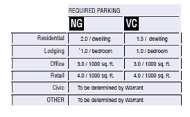 TABLE 12: Public Lighting. Lighting varies in brightness and also in the character of the fixture according to the District. The table shows three common types. A listed set of streetlights corresponding to these types would be approved by the utility company and listed on the page.
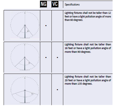 TABLE 13: Public Planting. This table shows a list of permitted street trees within each District. All trees are permitted within Civic Open Space regardless of the District.
 TABLE 14-a: Thoroughfare Assemblies. The key gives the thoroughfare type followed by the right-of-way width, followed by the pavement width. These dimensions are given as requirements to achieve the desired traffic speed. Rear Alleys and Lanes shall be privately owned and managed. These Thoroughfares are approved by right. Any other Thoroughfare constructed from Tables 4, 5 and 14 may be permitted by Warrant.
 TABLE 14-b: Thoroughfare Assemblies. The key gives the thoroughfare type followed by the right-of-way width, followed by the pavement width, and in some instances followed by specialized transportation capability. These dimensions are given as requirements to achieve the desired traffic speed. When used, Bicycle Lanes shall add 5 ft. to the outside lane of the thoroughfare and 10 ft. to the ROW. These Thoroughfares are approved by right. Any other Thoroughfare constructed from Tables 4, 5 and 14 may be permitted by Warrant.
 TABLE 14-c: Thoroughfare Assemblies. The key gives the thoroughfare type followed by the right-of-way width, followed by the pavement width, and in some instances followed by specialized transportation capability. These dimensions are given as requirements to achieve the desired traffic speed. When used, Bicycle Lanes shall be 5 ft. wide and add 10 ft. to the ROW. These Thoroughfares are approved by right. Any other Thoroughfare constructed from Tables 4, 5 and 14 may be permitted by Warrant.
 TABLE 14-d: Thoroughfare Assemblies. The key gives the thoroughfare type followed by the right-of-way width, followed by the pavement width, and in some instances followed by specialized transportation capability. These dimensions are given as requirements to achieve the desired traffic speed. When used, Bicycle Lanes shall be 5 ft. wide and add 10 ft. to the ROW. These Thoroughfares are approved by right. Any other Thoroughfare constructed from Tables 4, 5 and 14 may be permitted by Warrant.
 TABLE 14-e: Thoroughfare Assemblies. The following Thoroughfare is only permitted by Warrant. The key gives the thoroughfare type followed by right-of-way width, followed by the pavement width, and in some instances followed by specialized transportation capability. These dimensions are given as requirements to achieve the desired traffic speed. When used, Bicycle Lanes shall be 5 ft. wide and add 10 ft. to the ROW. This Thoroughfare is approved by right. Any other Thoroughfare constructed from Tables 4, 5 and 14 may be permitted by Warrant.

- Property can be annexed into the City as the PCMU Zone or rezoned to the PCMU Zone.
- The application for Planned Community Mixed-Use Zone Master Plan may be submitted in conjunction with the Annexation Application Package or the Rezone Package, or after an Annexation or Rezone is approved.
- Planned Community Mixed-Use Master Plans shall encompass annexed or rezoned area within the Heber City Municipal Code designated PCMU Zone. In the case of multiple master plans for one annexation or rezone area, each parcel shall submit a master plan.
- The applicant may be required to provide other information required by the Planning director or Planning Commission as necessary to evaluate the proposed application.
- Submittal Requirements. The following shall be submitted to the Planning director, along with the appropriate fees, at least four (4) weeks prior to the noticed Planning Commission public meeting.
- Annexation Application (See the Heber City Annexation Policy Plan) or the Rezone Application and General Plan Amendment (See the Heber City Code, Title 18).
- Master Plan Package – including the following:
- Vicinity Map
- Master Plan – showing entire project concept, densities, land uses, trails, open space, circulation and roads, and other site improvements and development concepts.
- Phasing Plan – master plan indicating phasing of entire project, with estimated time frames for development and a chart showing number of units and amenities per phase.
- Landscape Concept Plan – plan view of features such as: main entry, pocket parks, golf course, neighborhood entry and/or others.
- Environmental Features Map – showing approximate location of potential wetlands (Army Corps approved delineation required); ponds lakes, streams, canals or other bodies of water; slopes over 30%; potential geological hazards; fault lines; wildlife habitat; and stands of significant vegetation.
- Proposed Utility Plan – showing utilities available (if any) and proposed easement for new utility services or relocated utility services, and other proposed features such as systems of drainage, sewage and water supply.
- Proposed Streets – street widths and cross-sections.
- Architectural Design Guidelines.
- Traffic Study Analysis.
- Storm Water Management Master Plan.
- As applicable, a brief written statement from each of the following affected entities indicating the availability of current services, as well as the conditions and the impact of the development on such services:
- School District(s).
- Water Service District(s).
- Sewer Service District(s).
- Waste Removal and Disposal Service Provider(s).
- Water Canal Companies.
- Fire Department.
- Heber City Police.
- EMT Response/Protection Service Provider(s).
- Storm Water Management and Control Agency.
- School District(s).
- A Title Report for the property under the Master Plan provided by a Title Company and dated within 30 days of the date of Annexation Plan Submittal.
- Planned Community Mixed-Use Development Agreement – shall, at the minimum, include the following:
- A legal description of the land.
- A description of proposed density and uses for the project.
- A copy of the Master Plan package.
- A description of all Developer exactions or agreed upon public and private dedications and commitments.
- The Developer’s Agreement to pay specified service provider fees.
- The form of ownership anticipated for the project Property Owners Association and how the property will be maintained and used.
- Other specific requirements, rights, and peculiarities pertinent to the project.
- A legal description of the land.
- Approval of master Plan
- Submittal Procedure for the Planned Community Mixed-Use Master Plan.
- After receiving the applicant’s submittal, the Planning Director will review the submittal and determine if the required information provided is complete. The Planning Director will make a recommendation on the proposed plan to the Planning Commission and schedule the submittal for review on the Planning Commission’s next available agenda. If the Planning Director feels the applicant’s submittal is incomplete, the applicant has 90 days to submit the additional information requested to the Planning Director to continue the approval process.
- The Planning Commission will review the submittal and will make recommendations.
- Mayor and the Applicant(s) shall sign the Planned Community Mixed-Use Development Agreement as presented or as amended by the City Council. The Development Agreement shall be filed for recording with the County Recorder’s office at the Applicants’ expense.
- Once a Planned Community Development Agreement is signed by the Mayor and the Applicant, the project has received Master Plan approval. Only an approved Master Plan allows an Applicant to proceed with submittal of a Subdivision application. Master Plan approval is valid for two years from the date of approval. If after two (2) years form the date of approval, a subdivision application has not been filed with the City, the Master Plan is null and void. An extension may be requested by an Applicant and reviewed and approved by the City Council.
- After receiving the applicant’s submittal, the Planning Director will review the submittal and determine if the required information provided is complete. The Planning Director will make a recommendation on the proposed plan to the Planning Commission and schedule the submittal for review on the Planning Commission’s next available agenda. If the Planning Director feels the applicant’s submittal is incomplete, the applicant has 90 days to submit the additional information requested to the Planning Director to continue the approval process.
- Submittal Procedure for the Planned Community Mixed-Use Master Plan.
An approved Master Plan may be subdivided or re-subdivided at any time, subject to Title 17, Heber City Subdivision Ordinance for subdivision process and regulations. However, any such subdivision for a PCMU Zone shall be approved per the PCMU Zone requirements prior to submittal of a subdivision application.
- Required Procedures for Subdivision Application and Approval.
- Developer is not required to submit a Concept Plan and my opt to begin the process with the submittal of a Preliminary Plan. The submitted Master Plan may satisfy the Concept Plan.
- Developer is not required to submit a Concept Plan and my opt to begin the process with the submittal of a Preliminary Plan. The submitted Master Plan may satisfy the Concept Plan.
- Required Plans for Subdivision Application. Plans required for subdivision application, review and approval are the same as those described in Chapter 17.20, Section 17.20.020 Preliminary Plans and 17.20.030 Final Construction-Plans and Final Plat of Heber City Code (as revised). Additionally, the following information is required:
- Copy of Signed Development Agreement
- Location and acreage of open space and how that meets the open space requirements of the approved Master Plan
- If the applicant plans a phased development of the area contained in the subdivision, the respective areas of development shall be shown on the plan as to the area and priority of development
- Ownership
- The name and address of the owner or owners, the name and address of the developer if other than the owner, the name of the land surveyors, author of the title report, and the citation of last instrument conveying title to each parcel of property involved in the proposed development.
- Citation of any existing legal right-of-way or easements affecting the property.
- Existing covenants on the property, if any
- A copy of the project’s draft CC&R’s
- A copy of the declaration and by-laws of the development pursuant to the Utah Condominium Ownership Act (if applicable).
- Any special agreements, conveyances, easements, restrictions, conditions, which will govern the use, maintenance, and continued protection of the development and any of its common areas, open space and facilities
- Curb, Gutter and Sidewalks, Curb, gutter and sidewalks are required as per this Zone and following the Transect District requirements for each
- The name and address of the owner or owners, the name and address of the developer if other than the owner, the name of the land surveyors, author of the title report, and the citation of last instrument conveying title to each parcel of property involved in the proposed development.
- Copy of Signed Development Agreement
This Section provides definitions for Capitalized terms in this Code that are technical in nature or that otherwise may not reflect a common usage of the term. If a term is not defined in this Section, then the Heber City Planning Office shall determine the correct definition of the term.
- Building Style Definitions:
Accessory Unit: an apartment not greater than 600 square feet sharing ownership and utility connections with a principal building.
Apartment Building: a rearyard residential building type accommodating multiple dwellings disposed above and beside each other, sharing a common entry, accessed directly from and facing the street.
Ancillary Building: a building located in the rearyard of a lot, which it shares with a House, Cottage or Sideyard House. It generally faces on and is accessed from an alley.
Cottage: A single-family detached dwelling.
Duplex/Triplex/Quadplex: an edgeyard building type. A multi-family building, on a regular lot, shared with ancillary buildings in the rearyard. The main entrance to each dwelling is accessed directly from and faces the street. Multi-family applies to a building with two or more housing units that share one or more common walls.
Live-Work: a dwelling unit that contains, to a limited extent, a commercial component. A live-work unit is a fee simple unit on its own lot with the commercial component permitted anywhere in the building. It may be any disposition type.
Mixed-Use Block: a rearyard, flexible commercial building type. The Flex Building variant, for example, has dwellings allowed above and/or behind the commercial space, which is only allowed on the first floor. The main entrance to the building is accessed directly from and faces the street.
Rowhouse: a rearyard building type. A single-family dwelling with common walls on the side lot lines, the facades forming a continuous frontage line. Typically 2+ stories built to no minimum number of consecutive units.
Sideyard House: a sideyard building type. A single-family dwelling, which occupies one side of the lot, with the primary yard to the other side, shared with an ancillary building in the rearyard.
Single Family Detached House: an edgeyard building type. A single-family dwelling on a lot, often shared with an ancillary building in the rearyard.
Stacked Flats: Single Family attached units that share floors and ceilings with other units. Typically built with at least three stories.
Townhouse: A single family attached dwelling that share at least one side with a neighboring unit and is a minimum of two (2) stories. Typically built to the ROW line and in a series of three (3) to six (6) units. - General Definitions:
1st Layer: The 1st (first) layer of a lot is defined as the building setback.
2nd Layer: The 2nd (second) layer of a lot is defined as the area twenty (20) feet behind the front façade of the Principle Building.
3rd Layer: The 3rd layer is defined as any additional lot length behind the 2nd Layer.
Allee: a regularly spaced and aligned row of trees usually planted along a Thoroughfare or Pedestrian path.
Alley: See ‘Rear Alley’.
Backbuilding: a single-story structure connecting a Principle Building to an Outbuilding. See Table 3.
Basement: a below grade story of a building.
Bicycle Lane (BL): a dedicated bicycle lane running within a moderate-speed vehicular thoroughfare, demarcated by striping.
Bicycle Train (BT): a bicycle way running independently of a high-speed vehicular thoroughfare.
Civic: non-for-profit organizations dedicated to arts, culture, education, recreation, government, transit, and municipal parking.
Civic Building: a building designed specifically for a civic function. (i.e., churches, schools, community centers, meeting halls, fire or police stations, government offices, etc.)
Civic Space: an outdoor area dedicated for public use. Civic Space types are defined by the combination of certain physical constants including the relationship between their intended use, their size, their landscaping and their enfronting buildings (See Table 9).
Commercial: the term collectively defining workplace, office and retail functions.
Common Destination: An area of focused community activity defining the approximate center of a Walkable Neighborhood. It may include without limitation one or more of the following: A Civic Space, a Civic Building, a Commercial Center, a bus stop. A Common Destination may act as the social center of a Neighborhood.
Conditional Use: a ruling that would permit a practice that is not consistent with either a provision or the Intent of this Code. Conditional Uses are usually granted by the Planning Commission.
Density: the number of dwelling units within a standard measure of land area, usually given as units per acres.
Driveway: a vehicular lane within a lot, usually leading to a garage.
Enfront: to place an element along a frontage line, as in “porches enfront the street.”
Façade: the exterior wall of a building that is set along a Frontage Line.
Frontage Line: lot lines that coincide with a public frontage. Facades along Frontage Lines define the public realm and are therefore more regulated than the elevations that coincide with other Lot Lines (see Table 3).
Home Occupation: are businesses run out of homes. Refer to Heber City Code 18.108.020.
Impermeable Surface: Any ground level surface which does not allow water to percolate.
Liner Building: a building specifically designed to mask a parking lot or a parking garage from a frontage.
Lodging: premises available for daily and weekly renting of bedrooms.
Lot Coverage: The percentage of the lot covered with impermeable materials. This may include but is not limited to the primary and ancillary structures, driveways, walkways and paved patios.
Lot Line: the boundary that legally and geometrically demarcates a lot (see Frontage Line). Such lines appear graphically on Community and Site Plans. Codes reference lot lines as the baseline for measuring setbacks.
Meeting Hall: a building available for gatherings, including conferences. It should accommodate at least one room equivalent to a minimum of 10 square feet per projected dwelling unit within the Walkable Neighborhood in which the meeting hall is located. A Meeting Hall shall be completed upon the sale of 75% of the dwelling units. The Meeting Hall may be used for the marketing purposes of the development until the sale of 75% of the dwelling units, at which time control of its use shall be given to the local Community Organization.
Net Developable Area, Net Site Area: the developable areas of a site. The Net Site Area shall be allocated to the various Transect Districts according to the parameters in Table 2.
Office: premises available for the transaction of general business but excluding retail, artisan and manufacturing uses.
Open-Air Building: temporary or seasonal retail establishments which occupy a specific location but shall not be required to pay or sign lease agreements.
Opening: Any door, window, breeze-way or related feature on a building which permits occupants and/or light to move into and out of the building.
Outbuilding: an accessory building, usually located towards the rear of the same lot as a Principal Building. It is sometimes connected to the principal building by a Backbuilding. Outbuildings shall not exceed 600 square feet of net floor space, excluding parking areas.
Principle Building: The frontage facing building on any lot which is used as the lots primary functioning building.
Private Frontage: the privately held layer between the frontage line and the principal building façade. The structures and landscaping within the Private Frontage may be held to specific standards. The variables of Private Frontage are the depth of the setback and the combination of architectural elements such as fences, stoops, porches and galleries (see Table 6).
Public Frontage: the area between the curb of the vehicular lanes and the Frontage Lines. Elements of the Public Frontage include the type of curb, walk, planter, street tree and streetlight (see Table 4 and 5).
Rear Alley (AL): a vehicular driveway located to the rear of lots providing access to service areas and parking, and containing utility easements. Alleys should be paved from building face to building face, with drainage by inverted crown at the center or with roll curbs at the edges.
Rear Lane (LA): a vehicular driveway located to the rear of lots providing access to parking and outbuildings and containing utility easements. Rear lanes may be paved to driveway standards. Its streetscape consists of gravel or landscaped edges, no raised curb and is drained by percolation.
Residential: premises available for long-term human dwelling.
Retail: premises available for the sale of merchandise and food service.
Stoop: a Private Frontage wherein the Façade is aligned close to the Frontage Line with the First Story elevated from the Sidewalk for privacy, with an exterior stair and landing at the entrance.
Streetscreen: sometimes called Streetwall. A freestanding wall built along the frontage line or coplanar with the façade, often for the purpose of masking a parking lot from the thoroughfare. Streetscreens shall be between three (3) and six (6) feet in height and constructed of a material matching the adjacent building façade. The streetscreen may be a hedge or fence by Warrant. Streetscreens shall have openings no larger than is necessary to allow automobile and pedestrian access. In Addition, all streetscreens over four (4) feet high should be 30% permeable or articulated to avoid blank walls.
Story: a habitable level within a building of no more than fourteen (14) feet in height from finished floor to finished ceiling. Attics and raised basements are not considered stories for the purposes of determining building height.
Third Place: a private building that includes a space conducive to unstructured social gathering. Third Places are usually bars, cafes, and corner stores.
Thoroughfare: a vehicular way incorporating moving lanes and parking lanes within a right of way.
Transect Districts: Transect Districts are administratively similar to the landuse zones in conventional codes, except that in addition to the usual building use, density, height, and setback requirements, other elements of the intended habitat are integrated, including those of the private lot and building and the enfronting public streetscape. The elements are determined by their location on the Transect scale. The Transect Districts included in this Code are T3 Sub-Urban (Neighborhood General), T4 General Urban (Village Center) (see Table 1).
Walkable Neighborhood: an area, approximately circular, that is centered on a Common Destination. A Walkable Neighborhood is applied to determine the approximate size of a Neighborhood. A Standard Walkable Neighborhood is 1/4 mile radius or 1320 feet, about the distance of a five-minute walk at a leisurely pace. It has been shown that provided with a pedestrian environment, most people will walk this distance rather than drive.
Warrant: a ruling by the governing body be it a Development Review Committee (DRC) or a City, that would permit a practice that is not consistent with a specific provision of this Code, but is justified by its Intent.